|
|
|||||||||||||||||
| Point ID: 2921 | Downloads | Plots | Site Data | Code: 05MJ005 |
|
|
|||||||||||||||||
| Download | |
|---|---|
| Site Descriptor Information | Site Time Series Data |
| Link to all available data | |
|
|
| View: | Statistics | Time Series |
| Units: | m3/s |
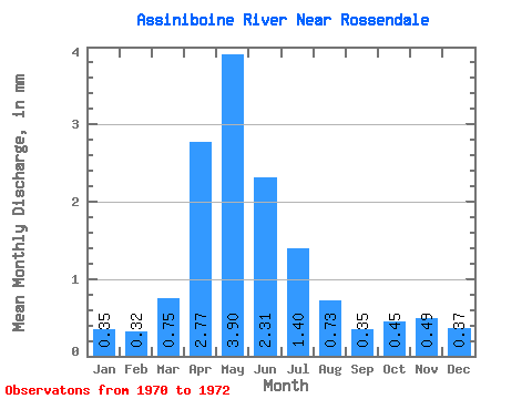
| Statistic | Jan | Feb | Mar | Apr | May | Jun | Jul | Aug | Sep | Oct | Nov | Dec | Annual |
|---|---|---|---|---|---|---|---|---|---|---|---|---|---|
| Mean | 0.35 | 0.32 | 0.75 | 2.77 | 3.90 | 2.31 | 1.40 | 0.73 | 0.35 | 0.45 | 0.49 | 0.37 | 12.53 |
| Standard Deviation | 0.12 | 0.12 | 0.54 | 0.88 | 1.59 | 0.71 | 0.68 | 0.32 | 0.06 | 0.05 | 0.07 | 0.09 | 1.93 |
| Min | 0.27 | 0.23 | 0.37 | 2.15 | 2.22 | 1.81 | 0.75 | 0.40 | 0.31 | 0.40 | 0.42 | 0.30 | 11.16 |
| Max | 0.43 | 0.41 | 1.14 | 3.39 | 5.39 | 3.12 | 2.11 | 1.03 | 0.42 | 0.49 | 0.57 | 0.47 | 13.89 |
| Coefficient of Variation | 0.34 | 0.38 | 0.72 | 0.32 | 0.41 | 0.30 | 0.49 | 0.43 | 0.17 | 0.10 | 0.15 | 0.24 | 0.15 |
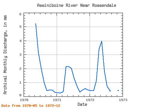
| Year | Jan | Feb | Mar | Apr | May | Jun | Jul | Aug | Sep | Oct | Nov | Dec | Annual | 1970 | 5.39 | 3.12 | 2.11 | 1.03 | 0.42 | 0.49 | 0.47 | 0.30 | 1971 | 0.27 | 0.23 | 0.37 | 2.15 | 2.22 | 2.01 | 1.34 | 0.76 | 0.31 | 0.48 | 0.57 | 0.47 | 11.16 | 1972 | 0.43 | 0.41 | 1.14 | 3.39 | 4.09 | 1.81 | 0.75 | 0.40 | 0.32 | 0.40 | 0.42 | 0.35 | 13.89 |
|---|
 Return to R-Arctic Net Home Page