|
|
|||||||||||||||||
| Point ID: 2889 | Downloads | Plots | Site Data | Code: 05MF005 |
|
|
|||||||||||||||||
| Download | |
|---|---|
| Site Descriptor Information | Site Time Series Data |
| Link to all available data | |
|
|
| View: | Statistics | Time Series |
| Units: | m3/s |
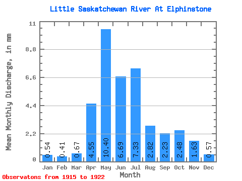
| Statistic | Jan | Feb | Mar | Apr | May | Jun | Jul | Aug | Sep | Oct | Nov | Dec | Annual |
|---|---|---|---|---|---|---|---|---|---|---|---|---|---|
| Mean | 0.55 | 0.41 | 0.67 | 4.55 | 10.40 | 6.69 | 7.33 | 2.82 | 2.23 | 2.48 | 1.64 | 0.56 | 86.66 |
| Standard Deviation | 0.59 | 0.41 | 0.58 | 3.13 | 7.62 | 4.82 | 9.13 | 2.70 | 1.44 | 1.57 | 0.65 | 0.65 | |
| Min | 0.13 | 0.12 | 0.26 | 0.95 | 1.03 | 2.06 | 1.63 | 0.48 | 0.72 | 0.93 | 0.83 | 0.08 | 86.66 |
| Max | 0.96 | 0.70 | 1.08 | 7.53 | 24.49 | 17.24 | 29.07 | 8.77 | 5.01 | 5.52 | 2.50 | 1.30 | 86.66 |
| Coefficient of Variation | 1.08 | 1.01 | 0.87 | 0.69 | 0.73 | 0.72 | 1.25 | 0.96 | 0.65 | 0.63 | 0.40 | 1.14 |
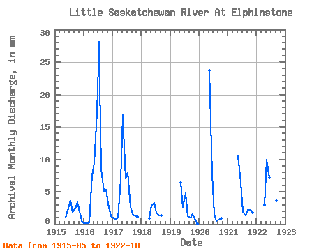
| Year | Jan | Feb | Mar | Apr | May | Jun | Jul | Aug | Sep | Oct | Nov | Dec | Annual | 1915 | 1.03 | 2.06 | 3.73 | 1.90 | 2.42 | 3.48 | 1.87 | 0.33 | 1916 | 0.13 | 0.12 | 0.26 | 7.53 | 9.73 | 17.24 | 29.07 | 8.77 | 5.01 | 5.52 | 2.50 | 1.30 | 86.66 | 1917 | 0.96 | 0.70 | 1.08 | 6.78 | 17.37 | 7.07 | 8.29 | 2.75 | 1.54 | 1.33 | 1.16 | 1918 | 0.95 | 2.93 | 3.23 | 1.86 | 1.39 | 1.30 | 1919 | 6.59 | 2.61 | 4.90 | 1.28 | 1.05 | 1.64 | 0.83 | 0.08 | 1920 | 24.49 | 7.71 | 1.63 | 0.48 | 0.72 | 0.93 | 1921 | 10.80 | 6.49 | 1.97 | 1.42 | 2.21 | 2.31 | 1.81 | 1922 | 2.95 | 10.23 | 7.13 | 7.21 | 4.58 | 3.59 | 2.15 |
|---|
 Return to R-Arctic Net Home Page