|
|
|||||||||||||||||
| Point ID: 285 | Downloads | Plots | Site Data | Code: 05BH006 |
|
|
|||||||||||||||||
| Download | |
|---|---|
| Site Descriptor Information | Site Time Series Data |
| Link to all available data | |
|
|
| View: | Statistics | Time Series |
| Units: | m3/s |
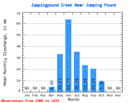
| Statistic | Jan | Feb | Mar | Apr | May | Jun | Jul | Aug | Sep | Oct | Nov | Dec | Annual |
|---|---|---|---|---|---|---|---|---|---|---|---|---|---|
| Mean | 4.48 | 33.27 | 63.70 | 35.28 | 23.38 | 20.55 | 9.18 | ||||||
| Standard Deviation | 27.57 | 75.90 | 48.94 | 24.38 | 34.04 | 8.54 | |||||||
| Min | 4.48 | 3.73 | 5.81 | 1.09 | 1.48 | 1.88 | 2.74 | ||||||
| Max | 4.48 | 94.17 | 248.95 | 161.27 | 80.63 | 124.76 | 24.72 | ||||||
| Coefficient of Variation | 0.83 | 1.19 | 1.39 | 1.04 | 1.66 | 0.93 |
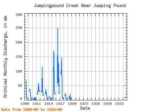
| Year | Jan | Feb | Mar | Apr | May | Jun | Jul | Aug | Sep | Oct | Nov | Dec | Annual | 1908 | 67.22 | 16.95 | 8.24 | 4.63 | 1909 | 37.14 | 30.42 | 20.25 | 10.30 | 3.98 | 3.33 | 1910 | 3.73 | 6.55 | 1.09 | 1.48 | 10.31 | 2.74 | 1911 | 21.19 | 34.92 | 34.26 | 59.45 | 29.62 | 1912 | 29.31 | 34.12 | 117.71 | 37.08 | 23.36 | 17.42 | 1913 | 23.95 | 35.72 | 19.78 | 22.25 | 8.37 | 4.39 | 1914 | 9.54 | 11.34 | 6.71 | 3.08 | 1.88 | 4.34 | 1915 | 4.48 | 56.97 | 168.05 | 161.27 | 40.08 | 22.22 | 21.54 | 1916 | 62.39 | 248.95 | 49.62 | 80.63 | 124.76 | 24.72 | 1917 | 94.17 | 146.97 | 12.36 | 8.83 | 8.89 | 6.12 | 1918 | 16.95 | 22.27 | 7.47 | 5.95 | 4.76 | 3.91 | 1919 | 10.59 | 5.81 | 2.83 | 19.30 | 3.81 | 3.30 | 1933 | 15.72 | 8.30 | 7.24 |
|---|
 Return to R-Arctic Net Home Page