|
|
|||||||||||||||||
| Point ID: 2817 | Downloads | Plots | Site Data | Code: 05LJ004 |
|
|
|||||||||||||||||
| Download | |
|---|---|
| Site Descriptor Information | Site Time Series Data |
| Link to all available data | |
|
|
| View: | Statistics | Time Series |
| Units: | m3/s |
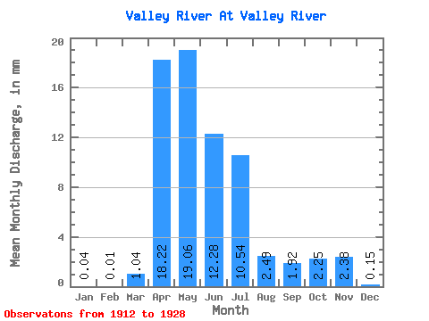
| Statistic | Jan | Feb | Mar | Apr | May | Jun | Jul | Aug | Sep | Oct | Nov | Dec | Annual |
|---|---|---|---|---|---|---|---|---|---|---|---|---|---|
| Mean | 0.04 | 0.01 | 1.04 | 18.22 | 19.06 | 12.28 | 10.54 | 2.49 | 1.92 | 2.25 | 2.38 | 0.15 | 41.04 |
| Standard Deviation | 0.05 | 0.02 | 2.05 | 17.61 | 16.05 | 10.54 | 11.39 | 2.47 | 1.64 | 1.71 | 3.32 | 0.09 | 21.64 |
| Min | 0.00 | 0.00 | 0.00 | 2.16 | 1.48 | 2.05 | 1.28 | 0.25 | 0.42 | 0.57 | 0.32 | 0.00 | 10.58 |
| Max | 0.11 | 0.05 | 5.58 | 48.31 | 65.38 | 37.74 | 40.47 | 7.95 | 5.74 | 6.26 | 11.34 | 0.28 | 67.28 |
| Coefficient of Variation | 1.31 | 1.68 | 1.98 | 0.97 | 0.84 | 0.86 | 1.08 | 0.99 | 0.85 | 0.76 | 1.40 | 0.61 | 0.53 |
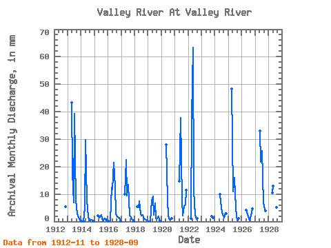
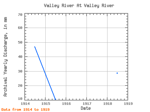
| Year | Jan | Feb | Mar | Apr | May | Jun | Jul | Aug | Sep | Oct | Nov | Dec | Annual | 1912 | 5.38 | 1913 | 43.17 | 18.31 | 6.88 | 40.47 | 7.95 | 2.88 | 1.82 | 1.10 | 0.28 | 1914 | 0.11 | 0.00 | 0.06 | 4.99 | 30.72 | 7.68 | 1.89 | 0.33 | 0.42 | 0.57 | 0.32 | 0.22 | 46.91 | 1915 | 0.00 | 0.00 | 0.00 | 2.16 | 1.48 | 2.05 | 2.52 | 0.25 | 0.56 | 1.06 | 0.52 | 0.00 | 10.58 | 1916 | 0.03 | 0.03 | 0.34 | 12.39 | 12.11 | 21.44 | 13.10 | 3.01 | 1.67 | 1.70 | 1.34 | 0.14 | 67.28 | 1917 | 0.00 | 0.00 | 0.00 | 10.01 | 23.24 | 9.38 | 13.88 | 2.17 | 1.88 | 0.94 | 0.69 | 0.10 | 61.88 | 1918 | 0.00 | 0.00 | 5.58 | 5.19 | 7.76 | 2.94 | 2.29 | 2.47 | 0.82 | 0.80 | 0.72 | 0.19 | 28.57 | 1919 | 0.10 | 0.05 | 0.06 | 7.76 | 9.39 | 2.30 | 6.83 | 1.18 | 1.01 | 1.92 | 0.47 | 0.11 | 30.99 | 1920 | 28.95 | 7.86 | 2.23 | 0.59 | 1.18 | 1.27 | 1921 | 15.06 | 37.74 | 8.00 | 2.30 | 5.74 | 6.26 | 11.34 | 1922 | 1.22 | 37.93 | 65.38 | 11.15 | 2.50 | 0.84 | 1.22 | 1923 | 1.85 | 1.35 | 1924 | 10.34 | 7.10 | 3.50 | 2.06 | 1.33 | 3.29 | 2.92 | 1925 | 48.31 | 11.22 | 16.01 | 10.24 | 1.30 | 0.46 | 1.10 | 1926 | 4.35 | 2.54 | 1.28 | 0.30 | 2.20 | 4.85 | 1927 | 34.16 | 21.82 | 26.68 | 7.24 | 5.40 | 4.00 | 1928 | 10.29 | 13.39 | 27.35 | 22.64 | 5.39 | 1.95 |
|---|
 Return to R-Arctic Net Home Page