|
|
|||||||||||||||||
| Point ID: 259 | Downloads | Plots | Site Data | Code: 05BF004 |
|
|
|||||||||||||||||
| Download | |
|---|---|
| Site Descriptor Information | Site Time Series Data |
| Link to all available data | |
|
|
| View: | Statistics | Time Series |
| Units: | m3/s |
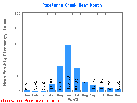
| Statistic | Jan | Feb | Mar | Apr | May | Jun | Jul | Aug | Sep | Oct | Nov | Dec | Annual |
|---|---|---|---|---|---|---|---|---|---|---|---|---|---|
| Mean | 5.23 | 3.47 | 3.53 | 19.52 | 64.64 | 116.50 | 58.88 | 25.88 | 16.74 | 12.57 | 8.78 | 6.50 | 435.83 |
| Standard Deviation | 0.51 | 0.19 | 0.24 | 21.18 | 38.42 | 59.97 | 22.78 | 10.75 | 9.30 | 6.45 | 4.61 | 0.80 | |
| Min | 4.88 | 3.33 | 3.36 | 6.18 | 34.35 | 49.24 | 23.67 | 11.56 | 8.67 | 5.09 | 1.87 | 5.93 | 435.83 |
| Max | 5.59 | 3.60 | 3.70 | 43.95 | 118.56 | 238.45 | 84.50 | 42.46 | 35.40 | 23.00 | 11.35 | 7.06 | 435.83 |
| Coefficient of Variation | 0.10 | 0.06 | 0.07 | 1.08 | 0.59 | 0.52 | 0.39 | 0.41 | 0.56 | 0.51 | 0.53 | 0.12 |
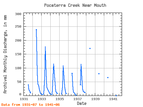
| Year | Jan | Feb | Mar | Apr | May | Jun | Jul | Aug | Sep | Oct | Nov | Dec | Annual | 1931 | 42.04 | 20.60 | 16.24 | 10.93 | 1932 | 238.45 | 84.50 | 42.46 | 35.40 | 23.00 | 11.11 | 5.93 | 1933 | 4.88 | 3.60 | 3.70 | 8.42 | 65.58 | 176.60 | 83.66 | 31.57 | 21.52 | 18.83 | 10.78 | 7.06 | 435.83 | 1934 | 5.59 | 3.33 | 3.36 | 43.95 | 118.56 | 85.45 | 44.98 | 16.23 | 9.48 | 8.87 | 1935 | 6.18 | 34.35 | 107.83 | 68.53 | 33.59 | 12.29 | 7.36 | 1936 | 80.16 | 23.67 | 11.56 | 8.67 | 5.09 | 1.87 | 1937 | 40.06 | 113.93 | 64.74 | 25.14 | 13.55 | 13.92 | 11.35 | 1938 | 170.09 | 1939 | 78.53 | 1940 | 64.70 | 1941 | 49.24 |
|---|
 Return to R-Arctic Net Home Page