|
|
|||||||||||||||||
| Point ID: 245 | Downloads | Plots | Site Data | Code: 05BD002 |
|
|
|||||||||||||||||
| Download | |
|---|---|
| Site Descriptor Information | Site Time Series Data |
| Link to all available data | |
|
|
| View: | Statistics | Time Series |
| Units: | m3/s |
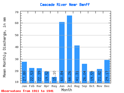
| Statistic | Jan | Feb | Mar | Apr | May | Jun | Jul | Aug | Sep | Oct | Nov | Dec | Annual |
|---|---|---|---|---|---|---|---|---|---|---|---|---|---|
| Mean | 27.79 | 22.72 | 22.39 | 19.52 | 15.10 | 60.84 | 66.25 | 41.31 | 26.04 | 19.59 | 21.82 | 29.16 | 379.42 |
| Standard Deviation | 10.92 | 9.37 | 9.85 | 11.59 | 12.16 | 40.02 | 35.39 | 20.61 | 11.10 | 6.22 | 11.54 | 15.46 | 85.41 |
| Min | 6.94 | 5.81 | 6.78 | 4.88 | 0.10 | 0.23 | 0.54 | 0.52 | 0.43 | 8.87 | 8.00 | 9.03 | 209.96 |
| Max | 48.80 | 43.36 | 44.36 | 48.41 | 66.55 | 146.78 | 167.38 | 90.34 | 51.53 | 31.74 | 53.87 | 72.60 | 557.33 |
| Coefficient of Variation | 0.39 | 0.41 | 0.44 | 0.59 | 0.81 | 0.66 | 0.53 | 0.50 | 0.43 | 0.32 | 0.53 | 0.53 | 0.23 |
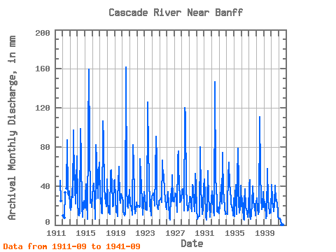
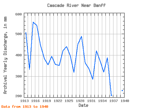
| Year | Jan | Feb | Mar | Apr | May | Jun | Jul | Aug | Sep | Oct | Nov | Dec | Annual | 1911 | 45.28 | 25.77 | 1912 | 8.86 | 7.38 | 34.44 | 38.64 | 90.34 | 31.97 | 31.74 | 32.09 | 35.85 | 1913 | 18.91 | 14.62 | 21.05 | 37.83 | 29.56 | 97.20 | 47.59 | 66.55 | 38.69 | 22.83 | 41.77 | 72.60 | 508.49 | 1914 | 24.80 | 9.55 | 11.21 | 9.99 | 13.99 | 98.37 | 71.39 | 19.64 | 8.20 | 23.47 | 24.83 | 18.03 | 333.03 | 1915 | 18.19 | 27.71 | 43.16 | 23.89 | 6.53 | 93.30 | 164.96 | 87.12 | 26.00 | 23.03 | 26.31 | 19.00 | 557.33 | 1916 | 31.14 | 36.12 | 44.36 | 26.93 | 6.49 | 46.84 | 85.10 | 68.97 | 47.23 | 28.35 | 53.87 | 66.14 | 541.01 | 1917 | 27.55 | 25.87 | 16.13 | 12.30 | 12.10 | 106.18 | 89.94 | 39.24 | 29.16 | 23.71 | 19.13 | 46.38 | 447.57 | 1918 | 48.80 | 24.62 | 13.15 | 19.52 | 11.45 | 55.82 | 58.08 | 39.44 | 26.31 | 19.32 | 19.87 | 47.19 | 383.01 | 1919 | 47.59 | 24.44 | 13.96 | 14.56 | 9.15 | 28.57 | 43.56 | 61.71 | 27.01 | 22.99 | 32.20 | 30.01 | 355.05 | 1920 | 29.24 | 21.98 | 15.53 | 11.24 | 9.64 | 10.81 | 167.38 | 41.14 | 19.13 | 18.11 | 26.74 | 26.14 | 394.26 | 1921 | 37.43 | 19.33 | 19.52 | 18.46 | 10.73 | 81.98 | 63.32 | 33.80 | 19.25 | 12.06 | 15.07 | 24.40 | 355.21 | 1922 | 19.08 | 18.70 | 20.73 | 18.23 | 19.52 | 67.92 | 53.64 | 41.95 | 23.46 | 10.85 | 22.72 | 35.41 | 352.00 | 1923 | 27.75 | 18.89 | 16.33 | 15.42 | 16.13 | 126.09 | 79.05 | 50.41 | 19.60 | 18.03 | 10.03 | 24.12 | 421.67 | 1924 | 30.09 | 28.48 | 33.35 | 30.53 | 20.17 | 52.70 | 93.97 | 68.97 | 24.24 | 18.47 | 15.93 | 25.09 | 440.80 | 1925 | 26.18 | 24.44 | 27.30 | 28.73 | 24.36 | 66.36 | 47.59 | 54.04 | 34.27 | 27.75 | 19.91 | 16.50 | 397.51 | 1926 | 30.21 | 32.12 | 33.56 | 22.84 | 7.78 | 5.58 | 33.23 | 24.80 | 51.53 | 25.65 | 25.49 | 24.48 | 318.10 | 1927 | 24.93 | 30.43 | 32.39 | 25.76 | 13.35 | 69.09 | 78.24 | 56.46 | 46.45 | 24.00 | 24.09 | 26.18 | 451.58 | 1928 | 37.23 | 34.47 | 32.67 | 22.05 | 14.92 | 120.23 | 114.94 | 37.35 | 25.22 | 15.08 | 15.19 | 20.00 | 489.84 | 1929 | 27.06 | 27.12 | 30.21 | 18.82 | 14.16 | 40.99 | 40.29 | 24.32 | 14.25 | 31.14 | 52.70 | 41.54 | 362.81 | 1930 | 17.42 | 5.81 | 7.74 | 9.13 | 9.03 | 80.02 | 79.05 | 37.39 | 24.40 | 11.25 | 17.33 | 40.29 | 337.62 | 1931 | 48.80 | 28.07 | 13.47 | 8.59 | 5.49 | 21.08 | 57.67 | 26.38 | 21.51 | 8.87 | 17.02 | 28.80 | 285.54 | 1932 | 27.02 | 32.74 | 27.71 | 14.40 | 10.37 | 146.78 | 49.20 | 39.73 | 24.12 | 14.28 | 13.47 | 18.88 | 420.80 | 1933 | 12.42 | 19.48 | 26.98 | 41.38 | 22.50 | 74.17 | 72.19 | 35.05 | 28.18 | 17.70 | 11.01 | 12.30 | 373.59 | 1934 | 12.34 | 10.18 | 21.94 | 48.41 | 66.55 | 39.82 | 39.12 | 24.16 | 18.62 | 17.46 | 12.10 | 9.84 | 319.64 | 1935 | 28.43 | 8.34 | 30.65 | 41.38 | 11.37 | 47.23 | 81.07 | 45.17 | 23.38 | 12.66 | 17.02 | 41.95 | 386.70 | 1936 | 19.80 | 25.80 | 19.16 | 6.17 | 5.57 | 22.33 | 38.07 | 18.91 | 16.36 | 13.59 | 8.00 | 15.77 | 209.96 | 1937 | 41.54 | 43.36 | 9.92 | 6.40 | 11.57 | 22.21 | 41.14 | 27.14 | 18.27 | 18.91 | 9.95 | 21.74 | 273.30 | 1938 | 23.39 | 26.16 | 17.34 | 10.81 | 14.84 | 110.47 | 57.67 | 27.39 | 27.87 | 16.58 | 19.44 | 35.33 | 388.36 | 1939 | 18.91 | 22.27 | 20.21 | 7.96 | 6.98 | 10.23 | 59.29 | 25.81 | 20.84 | 11.98 | 15.07 | 12.74 | 232.03 | 1940 | 42.75 | 25.36 | 22.75 | 21.70 | 14.20 | 21.82 | 41.54 | 25.29 | 26.11 | 21.94 | 14.52 | 9.03 | 287.04 | 1941 | 6.94 | 6.39 | 6.78 | 4.88 | 0.10 | 0.23 | 0.54 | 0.52 | 0.43 |
|---|
 Return to R-Arctic Net Home Page