|
|
|||||||||||||||||
| Point ID: 230 | Downloads | Plots | Site Data | Code: 05BA008 |
|
|
|||||||||||||||||
| Download | |
|---|---|
| Site Descriptor Information | Site Time Series Data |
| Link to all available data | |
|
|
| View: | Statistics | Time Series |
| Units: | m3/s |
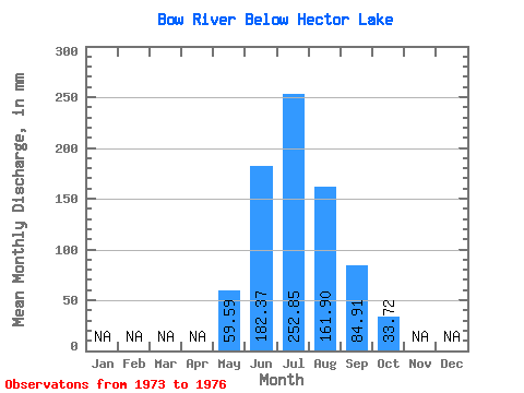
| Statistic | Jan | Feb | Mar | Apr | May | Jun | Jul | Aug | Sep | Oct | Nov | Dec | Annual |
|---|---|---|---|---|---|---|---|---|---|---|---|---|---|
| Mean | 59.59 | 182.37 | 252.82 | 161.88 | 84.91 | 33.71 | |||||||
| Standard Deviation | 37.15 | 68.41 | 13.40 | 36.14 | 36.96 | 5.26 | |||||||
| Min | 35.20 | 131.45 | 241.98 | 127.20 | 60.91 | 29.55 | |||||||
| Max | 102.34 | 260.13 | 267.80 | 210.41 | 138.86 | 41.41 | |||||||
| Coefficient of Variation | 0.62 | 0.38 | 0.05 | 0.22 | 0.43 | 0.16 |
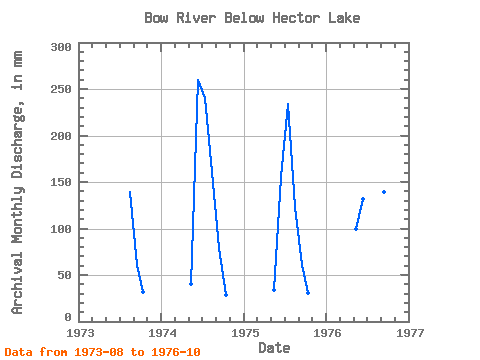
| Year | Jan | Feb | Mar | Apr | May | Jun | Jul | Aug | Sep | Oct | Nov | Dec | Annual | 1973 | 143.46 | 60.91 | 32.23 | 1974 | 41.22 | 260.13 | 248.67 | 166.42 | 78.96 | 29.55 | 1975 | 35.20 | 155.52 | 241.98 | 127.20 | 60.91 | 31.66 | 1976 | 102.34 | 131.45 | 267.80 | 210.41 | 138.86 | 41.41 |
|---|
 Return to R-Arctic Net Home Page