|
|
|||||||||||||||||
| Point ID: 119 | Downloads | Plots | Site Data | Code: 05AD904 |
|
|
|||||||||||||||||
| Download | |
|---|---|
| Site Descriptor Information | Site Time Series Data |
| Link to all available data | |
|
|
| View: | Statistics | Time Series |
| Units: | m3/s |
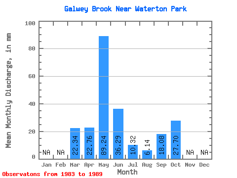
| Statistic | Jan | Feb | Mar | Apr | May | Jun | Jul | Aug | Sep | Oct | Nov | Dec | Annual |
|---|---|---|---|---|---|---|---|---|---|---|---|---|---|
| Mean | 22.34 | 22.73 | 89.16 | 36.31 | 10.27 | 6.14 | 18.12 | 27.71 | |||||
| Standard Deviation | 21.49 | 32.18 | 34.42 | 2.49 | 7.26 | 19.56 | 32.77 | ||||||
| Min | 22.34 | 0.25 | 56.43 | 10.75 | 6.92 | 0.26 | 0.25 | 0.26 | |||||
| Max | 22.34 | 46.91 | 130.63 | 101.66 | 13.85 | 18.29 | 53.86 | 75.38 | |||||
| Coefficient of Variation | 0.95 | 0.36 | 0.95 | 0.24 | 1.18 | 1.08 | 1.18 |
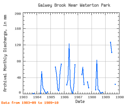
| Year | Jan | Feb | Mar | Apr | May | Jun | Jul | Aug | Sep | Oct | Nov | Dec | Annual | 1983 | 0.25 | 0.26 | 1984 | 0.25 | 56.43 | 14.29 | 10.71 | 3.13 | 1.39 | 4.96 | 1985 | 67.54 | 46.91 | 10.32 | 7.18 | 53.86 | 75.38 | 1986 | 22.34 | 34.01 | 127.11 | 21.37 | 6.92 | 0.26 | 17.57 | 73.55 | 1987 | 46.91 | 67.54 | 22.89 | 28.95 | 15.41 | 1988 | 9.74 | 85.70 | 10.75 | 9.54 | 1.83 | 1.52 | 3.00 | 1989 | 130.63 | 101.66 | 13.85 | 18.29 | 23.27 | 21.42 |
|---|
 Return to R-Arctic Net Home Page