|
|
|||||||||||||||||
| Point ID: 118 | Downloads | Plots | Site Data | Code: 05AD903 |
|
|
|||||||||||||||||
| Download | |
|---|---|
| Site Descriptor Information | Site Time Series Data |
| Link to all available data | |
|
|
| View: | Statistics | Time Series |
| Units: | m3/s |
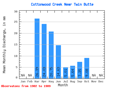
| Statistic | Jan | Feb | Mar | Apr | May | Jun | Jul | Aug | Sep | Oct | Nov | Dec | Annual |
|---|---|---|---|---|---|---|---|---|---|---|---|---|---|
| Mean | 26.35 | 24.02 | 20.72 | 14.61 | 5.00 | 5.66 | 7.37 | 9.10 | |||||
| Standard Deviation | 1.16 | 13.81 | 13.95 | 14.46 | 5.49 | 8.96 | 6.50 | 8.41 | |||||
| Min | 25.53 | 7.35 | 5.17 | 4.02 | 0.63 | 0.00 | 0.00 | 0.00 | |||||
| Max | 27.17 | 48.20 | 47.14 | 39.71 | 14.80 | 23.65 | 16.37 | 23.34 | |||||
| Coefficient of Variation | 0.04 | 0.57 | 0.67 | 0.99 | 1.10 | 1.58 | 0.88 | 0.93 |
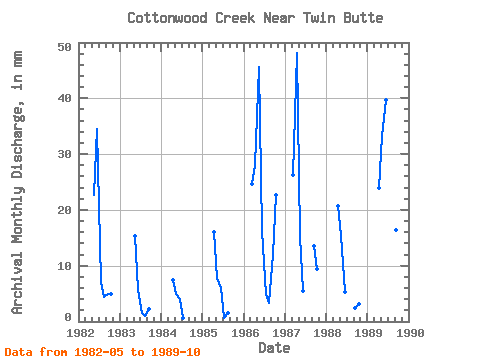
| Year | Jan | Feb | Mar | Apr | May | Jun | Jul | Aug | Sep | Oct | Nov | Dec | Annual | 1982 | 23.41 | 34.48 | 7.28 | 4.46 | 4.93 | 5.01 | 1983 | 15.82 | 5.68 | 1.57 | 0.94 | 2.20 | 1984 | 7.35 | 5.17 | 4.02 | 0.63 | 0.00 | 0.00 | 0.00 | 1985 | 15.99 | 8.14 | 6.06 | 0.70 | 1.57 | 1986 | 25.53 | 27.97 | 47.14 | 16.14 | 5.01 | 3.37 | 12.13 | 23.34 | 1987 | 27.17 | 48.20 | 15.90 | 5.53 | 13.57 | 9.63 | 1988 | 20.77 | 15.82 | 5.23 | 2.42 | 3.29 | 1989 | 23.87 | 34.38 | 39.71 | 14.80 | 23.65 | 16.37 | 13.31 |
|---|
 Return to R-Arctic Net Home Page