|
|
|||||||||||||||||
| Point ID: 9668 | Downloads | Plots | Site Data | Code: 05124480 |
|
|
|||||||||||||||||
| Download | |
|---|---|
| Site Descriptor Information | Site Time Series Data |
| Link to all available data | |
| View: | Time Series | All |
| Units: | m3/s |
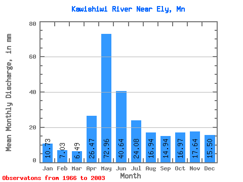
| Statistic | Jan | Feb | Mar | Apr | May | Jun | Jul | Aug | Sep | Oct | Nov | Dec | Annual |
|---|---|---|---|---|---|---|---|---|---|---|---|---|---|
| Mean | 10.72 | 7.09 | 6.49 | 26.47 | 72.95 | 40.64 | 24.08 | 16.94 | 14.94 | 16.96 | 17.64 | 15.50 | 273.68 |
| Standard Deviation | 4.97 | 2.56 | 1.77 | 19.49 | 33.46 | 23.13 | 12.38 | 15.34 | 16.83 | 19.48 | 16.64 | 10.46 | 73.66 |
| Min | 0.61 | 0.50 | 0.68 | 1.00 | 1.54 | 12.86 | 7.50 | 4.15 | 2.07 | 1.40 | 1.05 | 0.84 | 144.62 |
| Max | 18.76 | 11.19 | 9.82 | 87.59 | 130.57 | 119.32 | 60.30 | 87.34 | 77.88 | 101.60 | 76.26 | 39.79 | 465.43 |
| Coefficient of Variation | 0.46 | 0.36 | 0.27 | 0.74 | 0.46 | 0.57 | 0.51 | 0.91 | 1.13 | 1.15 | 0.94 | 0.68 | 0.27 |
 Return to R-Arctic Net Home Page