|
|
|||||||||||||||||
| Point ID: 9611 | Downloads | Plots | Site Data | Code: 05051650 |
|
|
|||||||||||||||||
| Download | |
|---|---|
| Site Descriptor Information | Site Time Series Data |
| Link to all available data | |
|
|
| View: | Statistics | Time Series |
| Units: | mm |
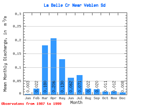
| Statistic | Jan | Feb | Mar | Apr | May | Jun | Jul | Aug | Sep | Oct | Nov | Dec | Annual |
|---|---|---|---|---|---|---|---|---|---|---|---|---|---|
| Mean | 0.00 | 0.02 | 0.18 | 0.21 | 0.13 | 0.06 | 0.07 | 0.02 | 0.02 | 0.01 | 0.01 | 0.01 | 0.06 |
| Standard Deviation | 0.01 | 0.03 | 0.19 | 0.20 | 0.14 | 0.07 | 0.11 | 0.06 | 0.06 | 0.02 | 0.02 | 0.01 | 0.05 |
| Min | 0.00 | 0.00 | 0.01 | 0.01 | 0.00 | 0.00 | 0.00 | 0.00 | 0.00 | 0.00 | 0.00 | 0.00 | 0.00 |
| Max | 0.02 | 0.09 | 0.64 | 0.59 | 0.43 | 0.18 | 0.40 | 0.21 | 0.20 | 0.06 | 0.08 | 0.05 | 0.12 |
| Coefficient of Variation | 1.58 | 1.36 | 1.05 | 0.96 | 1.10 | 1.05 | 1.55 | 2.70 | 2.83 | 1.70 | 1.98 | 1.97 | 0.80 |
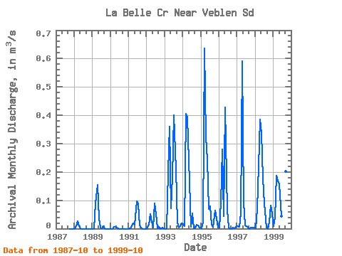
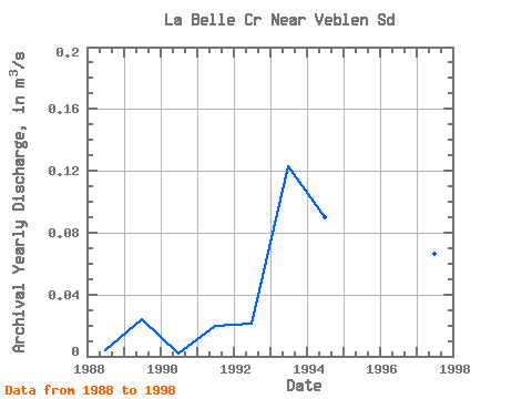
| Year | Jan | Feb | Mar | Apr | May | Jun | Jul | Aug | Sep | Oct | Nov | Dec | Annual | 1987 | 0.00 | 0.00 | 0.00 | 1988 | 0.00 | 0.01 | 0.03 | 0.01 | 0.00 | 0.00 | 0.00 | 0.00 | 0.00 | 0.00 | 0.00 | 0.00 | 0.00 | 1989 | 0.00 | 0.00 | 0.09 | 0.15 | 0.03 | 0.00 | 0.00 | 0.01 | 0.00 | 0.00 | 0.00 | 0.00 | 0.02 | 1990 | 0.00 | 0.00 | 0.01 | 0.01 | 0.00 | 0.00 | 0.00 | 0.00 | 0.00 | 0.00 | 0.00 | 0.00 | 0.00 | 1991 | 0.00 | 0.00 | 0.01 | 0.02 | 0.01 | 0.10 | 0.09 | 0.01 | 0.00 | 0.00 | 0.00 | 0.00 | 0.02 | 1992 | 0.00 | 0.01 | 0.05 | 0.02 | 0.00 | 0.09 | 0.05 | 0.00 | 0.01 | 0.00 | 0.00 | 0.00 | 0.02 | 1993 | 0.00 | 0.00 | 0.20 | 0.36 | 0.07 | 0.18 | 0.40 | 0.21 | 0.02 | 0.01 | 0.01 | 0.02 | 0.12 | 1994 | 0.02 | 0.01 | 0.40 | 0.39 | 0.17 | 0.01 | 0.06 | 0.00 | 0.00 | 0.01 | 0.01 | 0.00 | 0.09 | 1995 | 0.00 | 0.02 | 0.64 | 0.32 | 0.24 | 0.07 | 0.08 | 0.01 | 0.01 | 0.06 | 0.03 | 0.00 | 0.12 | 1996 | 0.00 | 0.09 | 0.28 | 0.04 | 0.43 | 0.07 | 0.00 | 0.00 | 0.00 | 0.00 | 0.00 | 0.01 | 0.08 | 1997 | 0.01 | 0.01 | 0.06 | 0.59 | 0.10 | 0.01 | 0.01 | 0.00 | 0.00 | 0.00 | 0.01 | 0.00 | 0.07 | 1998 | 0.00 | 0.07 | 0.22 | 0.38 | 0.34 | 0.18 | 0.09 | 0.00 | 0.00 | 0.02 | 0.08 | 0.05 | 0.12 | 1999 | 0.01 | 0.04 | 0.19 | 0.17 | 0.16 | 0.04 | 0.08 | 0.01 | 0.20 | 0.03 |
|---|
 Return to R-Arctic Net Home Page