|
|
|||||||||||||||||
| Point ID: 9582 | Downloads | Plots | Site Data | Code: 05109000 |
|
|
|||||||||||||||||
| Download | |
|---|---|
| Site Descriptor Information | Site Time Series Data |
| Link to all available data | |
|
|
| View: | Statistics | Time Series |
| Units: | mm |
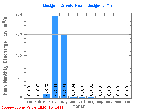
| Statistic | Jan | Feb | Mar | Apr | May | Jun | Jul | Aug | Sep | Oct | Nov | Dec | Annual |
|---|---|---|---|---|---|---|---|---|---|---|---|---|---|
| Mean | 0.00 | 0.00 | 0.02 | 0.38 | 0.29 | 0.00 | 0.01 | 0.00 | 0.00 | 0.00 | 0.00 | 0.00 | 0.06 |
| Standard Deviation | 0.00 | 0.00 | 0.04 | 0.34 | 0.37 | 0.01 | 0.02 | 0.01 | 0.00 | 0.00 | 0.00 | 0.00 | 0.06 |
| Min | 0.00 | 0.00 | 0.00 | 0.04 | 0.00 | 0.00 | 0.00 | 0.00 | 0.00 | 0.00 | 0.00 | 0.00 | 0.00 |
| Max | 0.00 | 0.00 | 0.10 | 1.07 | 0.90 | 0.02 | 0.05 | 0.03 | 0.00 | 0.00 | 0.00 | 0.00 | 0.16 |
| Coefficient of Variation | 1.83 | 0.88 | 1.26 | 1.75 | 3.00 | 3.00 | 0.97 |
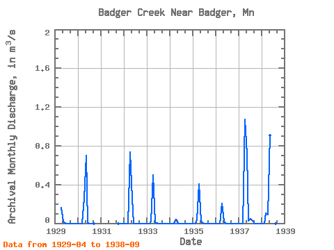
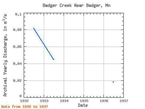
| Year | Jan | Feb | Mar | Apr | May | Jun | Jul | Aug | Sep | Oct | Nov | Dec | Annual | 1929 | 0.16 | 0.02 | 0.00 | 0.00 | 0.00 | 0.00 | 0.00 | 0.00 | 0.00 | 1930 | 0.00 | 0.00 | 0.00 | 0.25 | 0.70 | 0.00 | 0.00 | 0.00 | 0.00 | 1931 | 0.00 | 0.00 | 0.00 | 1932 | 0.00 | 0.00 | 0.00 | 0.73 | 0.25 | 0.00 | 0.00 | 0.00 | 0.00 | 0.00 | 0.00 | 0.00 | 0.08 | 1933 | 0.00 | 0.00 | 0.02 | 0.50 | 0.01 | 0.00 | 0.00 | 0.00 | 0.00 | 0.00 | 0.00 | 0.00 | 0.04 | 1934 | 0.00 | 0.00 | 0.00 | 0.04 | 0.00 | 0.00 | 0.00 | 0.00 | 0.00 | 0.00 | 0.00 | 0.00 | 0.00 | 1935 | 0.00 | 0.00 | 0.04 | 0.41 | 0.03 | 0.00 | 0.00 | 0.00 | 0.00 | 0.00 | 0.00 | 0.00 | 0.04 | 1936 | 0.00 | 0.00 | 0.00 | 0.21 | 0.01 | 0.00 | 0.00 | 0.00 | 0.00 | 0.00 | 0.00 | 0.00 | 0.02 | 1937 | 0.00 | 0.00 | 0.00 | 1.07 | 0.71 | 0.02 | 0.05 | 0.03 | 0.00 | 0.00 | 0.00 | 0.00 | 0.16 | 1938 | 0.00 | 0.00 | 0.10 | 0.09 | 0.90 | 0.00 | 0.00 | 0.00 | 0.00 |
|---|
 Return to R-Arctic Net Home Page