|
|
|||||||||||||||||
| Point ID: 9572 | Downloads | Plots | Site Data | Code: 05127207 |
|
|
|||||||||||||||||
| Download | |
|---|---|
| Site Descriptor Information | Site Time Series Data |
| Link to all available data | |
| View: | Time Series | All |
| Units: | m3/s |
| Statistic | Jan | Feb | Mar | Apr | May | Jun | Jul | Aug | Sep | Oct | Nov | Dec | Annual |
|---|---|---|---|---|---|---|---|---|---|---|---|---|---|
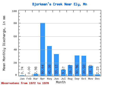
| Mean | 0.69 | 0.11 | 2.66 | 80.96 | 45.10 | 33.12 | 9.56 | 16.70 | 31.07 | 30.29 | 15.06 | 2.59 | 275.88 |
| Standard Deviation | 0.88 | 0.28 | 4.94 | 44.98 | 24.81 | 11.41 | 6.52 | 18.43 | 48.56 | 42.43 | 14.59 | 4.27 | 83.15 |
| Min | 0.00 | 0.00 | 0.00 | 8.21 | 6.02 | 11.95 | 1.49 | 0.00 | 0.00 | 0.00 | 0.00 | 0.00 | 168.93 |
| Max | 2.14 | 0.68 | 12.62 | 123.48 | 75.01 | 46.15 | 17.11 | 46.24 | 136.61 | 103.40 | 38.78 | 11.16 | 388.92 |
| Coefficient of Variation | 1.27 | 2.45 | 1.86 | 0.56 | 0.55 | 0.34 | 0.68 | 1.10 | 1.56 | 1.40 | 0.97 | 1.65 | 0.30 |
 Return to R-Arctic Net Home Page