|
|
|||||||||||||||||
| Point ID: 9569 | Downloads | Plots | Site Data | Code: 05063000 |
|
|
|||||||||||||||||
| Download | |
|---|---|
| Site Descriptor Information | Site Time Series Data |
| Link to all available data | |
|
|
| View: | Statistics | Time Series |
| Units: | mm |
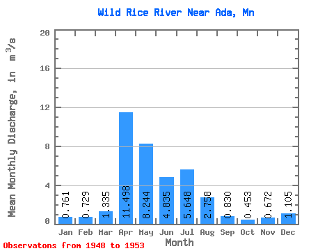
| Statistic | Jan | Feb | Mar | Apr | May | Jun | Jul | Aug | Sep | Oct | Nov | Dec | Annual |
|---|---|---|---|---|---|---|---|---|---|---|---|---|---|
| Mean | 0.76 | 0.73 | 1.33 | 11.50 | 8.24 | 4.83 | 5.65 | 2.76 | 0.83 | 0.45 | 0.67 | 1.10 | 3.20 |
| Standard Deviation | 1.06 | 0.86 | 1.23 | 5.87 | 7.11 | 5.40 | 5.32 | 3.10 | 0.98 | 0.56 | 0.69 | 1.52 | 1.47 |
| Min | 0.00 | 0.00 | 0.00 | 3.98 | 2.83 | 0.12 | 0.02 | 0.00 | 0.00 | 0.00 | 0.00 | 0.00 | 1.44 |
| Max | 2.52 | 2.02 | 2.81 | 20.57 | 21.60 | 12.41 | 13.22 | 6.32 | 2.31 | 1.37 | 1.53 | 3.63 | 4.67 |
| Coefficient of Variation | 1.39 | 1.18 | 0.92 | 0.51 | 0.86 | 1.12 | 0.94 | 1.12 | 1.18 | 1.24 | 1.03 | 1.37 | 0.46 |
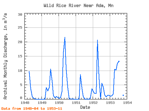
| Year | Jan | Feb | Mar | Apr | May | Jun | Jul | Aug | Sep | Oct | Nov | Dec | Annual | 1948 | 9.60 | 3.65 | 0.76 | 0.41 | 0.00 | 0.00 | 0.00 | 0.00 | 0.00 | 1949 | 0.00 | 0.00 | 0.00 | 3.98 | 2.83 | 4.10 | 10.46 | 6.32 | 1.19 | 0.54 | 0.91 | 0.54 | 2.57 | 1950 | 0.31 | 0.50 | 2.81 | 15.93 | 21.60 | 10.66 | 4.21 | 0.04 | 0.00 | 0.00 | 0.00 | 0.00 | 4.67 | 1951 | 0.00 | 0.00 | 0.11 | 8.51 | 3.82 | 0.95 | 0.02 | 0.00 | 0.00 | 0.00 | 0.23 | 3.63 | 1.44 | 1952 | 2.52 | 2.02 | 1.96 | 20.57 | 7.44 | 0.12 | 5.56 | 4.14 | 1.48 | 0.81 | 1.37 | 1.35 | 4.11 | 1953 | 0.98 | 1.13 | 1.80 | 10.41 | 10.12 | 12.41 | 13.22 | 6.04 | 2.31 | 1.37 | 1.53 |
|---|
 Return to R-Arctic Net Home Page