|
|
|||||||||||||||||
| Point ID: 9562 | Downloads | Plots | Site Data | Code: 05056636 |
|
|
|||||||||||||||||
| Download | |
|---|---|
| Site Descriptor Information | Site Time Series Data |
| Link to all available data | |
|
|
| View: | Statistics | Time Series |
| Units: | mm |
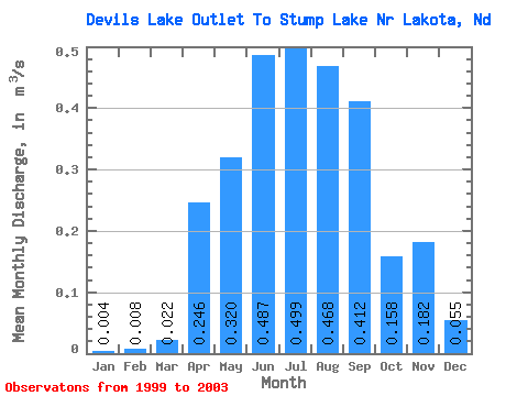
| Statistic | Jan | Feb | Mar | Apr | May | Jun | Jul | Aug | Sep | Oct | Nov | Dec | Annual |
|---|---|---|---|---|---|---|---|---|---|---|---|---|---|
| Mean | 0.00 | 0.01 | 0.02 | 0.25 | 0.32 | 0.49 | 0.50 | 0.47 | 0.41 | 0.16 | 0.18 | 0.06 | 0.33 |
| Standard Deviation | 0.00 | 0.02 | 0.02 | 0.20 | 0.25 | 0.31 | 0.32 | 0.34 | 0.24 | 0.20 | 0.19 | 0.07 | 0.01 |
| Min | 0.00 | 0.00 | 0.00 | 0.00 | 0.00 | 0.04 | 0.02 | 0.00 | 0.13 | 0.00 | 0.00 | 0.00 | 0.33 |
| Max | 0.01 | 0.03 | 0.05 | 0.41 | 0.52 | 0.71 | 0.73 | 0.83 | 0.56 | 0.42 | 0.36 | 0.13 | 0.34 |
| Coefficient of Variation | 1.00 | 2.00 | 1.05 | 0.80 | 0.77 | 0.63 | 0.65 | 0.73 | 0.60 | 1.27 | 1.03 | 1.19 | 0.03 |
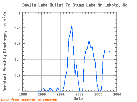
| Year | Jan | Feb | Mar | Apr | May | Jun | Jul | Aug | Sep | Oct | Nov | Dec | Annual | 1999 | 0.00 | 0.00 | 0.00 | 2000 | 0.03 | 0.01 | 0.00 | 0.00 | 0.04 | 0.02 | 0.00 | 0.01 | 0.04 | 0.00 | 2001 | 0.00 | 0.00 | 0.05 | 0.18 | 0.26 | 0.66 | 0.73 | 0.83 | 0.54 | 0.20 | 0.33 | 0.13 | 0.33 | 2002 | 0.00 | 0.00 | 0.00 | 0.40 | 0.52 | 0.54 | 0.64 | 0.55 | 0.56 | 0.42 | 0.36 | 0.09 | 0.34 | 2003 | 0.01 | 0.00 | 0.02 | 0.41 | 0.51 | 0.71 | 0.60 | 0.50 | 0.13 |
|---|
 Return to R-Arctic Net Home Page