|
|
|||||||||||||||||
| Point ID: 9558 | Downloads | Plots | Site Data | Code: 05033900 |
|
|
|||||||||||||||||
| Download | |
|---|---|
| Site Descriptor Information | Site Time Series Data |
| Link to all available data | |
|
|
| View: | Statistics | Time Series |
| Units: | mm |
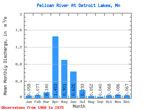
| Statistic | Jan | Feb | Mar | Apr | May | Jun | Jul | Aug | Sep | Oct | Nov | Dec | Annual |
|---|---|---|---|---|---|---|---|---|---|---|---|---|---|
| Mean | 0.06 | 0.08 | 0.14 | 1.45 | 0.90 | 0.63 | 0.19 | 0.05 | 0.04 | 0.07 | 0.09 | 0.07 | 0.28 |
| Standard Deviation | 0.05 | 0.07 | 0.11 | 0.67 | 0.46 | 0.48 | 0.09 | 0.01 | 0.01 | 0.03 | 0.01 | 0.05 | 0.03 |
| Min | 0.03 | 0.03 | 0.05 | 0.82 | 0.44 | 0.22 | 0.10 | 0.04 | 0.02 | 0.04 | 0.07 | 0.03 | 0.26 |
| Max | 0.13 | 0.18 | 0.30 | 2.05 | 1.53 | 1.25 | 0.31 | 0.07 | 0.05 | 0.09 | 0.10 | 0.15 | 0.29 |
| Coefficient of Variation | 0.79 | 0.90 | 0.76 | 0.46 | 0.51 | 0.77 | 0.47 | 0.26 | 0.38 | 0.42 | 0.18 | 0.80 | 0.10 |
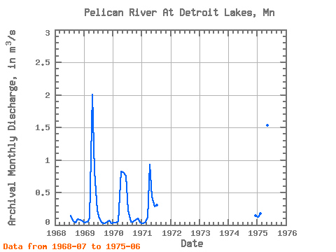
| Year | Jan | Feb | Mar | Apr | May | Jun | Jul | Aug | Sep | Oct | Nov | Dec | Annual | 1968 | 0.15 | 0.07 | 0.04 | 0.09 | 0.09 | 0.05 | 1969 | 0.04 | 0.05 | 0.10 | 2.01 | 0.82 | 0.22 | 0.10 | 0.04 | 0.02 | 0.04 | 0.07 | 0.03 | 0.29 | 1970 | 0.04 | 0.04 | 0.05 | 0.82 | 0.81 | 0.75 | 0.22 | 0.05 | 0.05 | 0.08 | 0.10 | 0.04 | 0.26 | 1971 | 0.03 | 0.03 | 0.11 | 0.93 | 0.44 | 0.28 | 0.31 | 1974 | 0.15 | 1975 | 0.13 | 0.18 | 0.30 | 2.05 | 1.53 | 1.25 |
|---|
 Return to R-Arctic Net Home Page