|
|
|||||||||||||||||
| Point ID: 9539 | Downloads | Plots | Site Data | Code: 05073900 |
|
|
|||||||||||||||||
| Download | |
|---|---|
| Site Descriptor Information | Site Time Series Data |
| Link to all available data | |
|
|
| View: | Statistics | Time Series |
| Units: | mm |
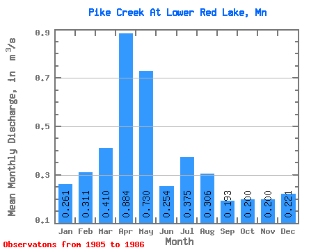
| Statistic | Jan | Feb | Mar | Apr | May | Jun | Jul | Aug | Sep | Oct | Nov | Dec | Annual |
|---|---|---|---|---|---|---|---|---|---|---|---|---|---|
| Mean | 0.26 | 0.31 | 0.41 | 0.88 | 0.73 | 0.25 | 0.38 | 0.31 | 0.19 | 0.20 | 0.20 | 0.22 | |
| Standard Deviation | 0.08 | 0.02 | 0.03 | 0.02 | |||||||||
| Min | 0.26 | 0.31 | 0.41 | 0.88 | 0.73 | 0.25 | 0.32 | 0.29 | 0.17 | 0.18 | 0.20 | 0.22 | |
| Max | 0.26 | 0.31 | 0.41 | 0.88 | 0.73 | 0.25 | 0.43 | 0.32 | 0.21 | 0.22 | 0.20 | 0.22 | |
| Coefficient of Variation | 0.21 | 0.06 | 0.15 | 0.12 |
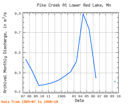
| Year | Jan | Feb | Mar | Apr | May | Jun | Jul | Aug | Sep | Oct | Nov | Dec | Annual | 1985 | 0.43 | 0.32 | 0.17 | 0.18 | 0.20 | 0.22 | 1986 | 0.26 | 0.31 | 0.41 | 0.88 | 0.73 | 0.25 | 0.32 | 0.29 | 0.21 | 0.22 |
|---|
 Return to R-Arctic Net Home Page