|
|
|||||||||||||||||
| Point ID: 9495 | Downloads | Plots | Site Data | Code: 15296550 |
|
|
|||||||||||||||||
| Download | |
|---|---|
| Site Descriptor Information | Site Time Series Data |
| Link to all available data | |
| View: | Time Series | All |
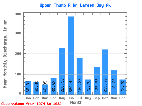
| Units: | m3/s |
| Statistic | Jan | Feb | Mar | Apr | May | Jun | Jul | Aug | Sep | Oct | Nov | Dec | Annual |
|---|---|---|---|---|---|---|---|---|---|---|---|---|---|
| Mean | 68.31 | 61.34 | 48.94 | 80.62 | 228.47 | 380.47 | 180.24 | 73.70 | 135.91 | 219.69 | 118.28 | 73.66 | 1706.32 |
| Standard Deviation | 49.75 | 40.76 | 24.77 | 52.66 | 55.49 | 132.55 | 80.07 | 35.11 | 61.76 | 71.26 | 77.24 | 50.38 | 248.29 |
| Min | 24.01 | 17.32 | 14.55 | 27.72 | 170.24 | 246.06 | 41.74 | 48.93 | 62.70 | 122.71 | 40.80 | 23.04 | 1419.39 |
| Max | 167.01 | 126.52 | 84.74 | 192.41 | 318.56 | 646.26 | 308.88 | 152.70 | 232.50 | 361.55 | 284.34 | 149.94 | 2020.20 |
| Coefficient of Variation | 0.73 | 0.66 | 0.51 | 0.65 | 0.24 | 0.35 | 0.44 | 0.48 | 0.45 | 0.32 | 0.65 | 0.68 | 0.15 |
 Return to R-Arctic Net Home Page