|
|
|||||||||||||||||
| Point ID: 9491 | Downloads | Plots | Site Data | Code: 15294100 |
|
|
|||||||||||||||||
| Download | |
|---|---|
| Site Descriptor Information | Site Time Series Data |
| Link to all available data | |
| View: | Time Series | All |
| Units: | m3/s |
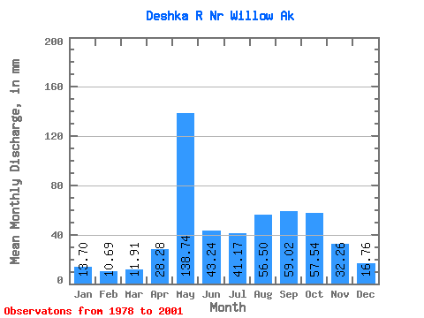
| Statistic | Jan | Feb | Mar | Apr | May | Jun | Jul | Aug | Sep | Oct | Nov | Dec | Annual |
|---|---|---|---|---|---|---|---|---|---|---|---|---|---|
| Mean | 13.70 | 10.79 | 11.90 | 28.28 | 138.72 | 43.24 | 41.16 | 56.49 | 59.02 | 57.53 | 32.26 | 16.76 | 523.67 |
| Standard Deviation | 3.21 | 2.39 | 2.68 | 14.14 | 55.23 | 23.56 | 35.23 | 31.74 | 37.68 | 22.25 | 32.47 | 5.49 | 116.86 |
| Min | 9.45 | 8.22 | 8.79 | 10.32 | 67.41 | 20.19 | 12.24 | 19.76 | 21.23 | 23.78 | 13.30 | 10.78 | 315.52 |
| Max | 19.46 | 16.34 | 16.46 | 58.24 | 216.33 | 91.65 | 127.80 | 134.45 | 122.82 | 86.60 | 127.96 | 27.81 | 656.87 |
| Coefficient of Variation | 0.23 | 0.22 | 0.23 | 0.50 | 0.40 | 0.55 | 0.86 | 0.56 | 0.64 | 0.39 | 1.01 | 0.33 | 0.22 |
 Return to R-Arctic Net Home Page