|
|
|||||||||||||||||
| Point ID: 9488 | Downloads | Plots | Site Data | Code: 15295600 |
|
|
|||||||||||||||||
| Download | |
|---|---|
| Site Descriptor Information | Site Time Series Data |
| Link to all available data | |
| View: | Time Series | All |
| Units: | m3/s |
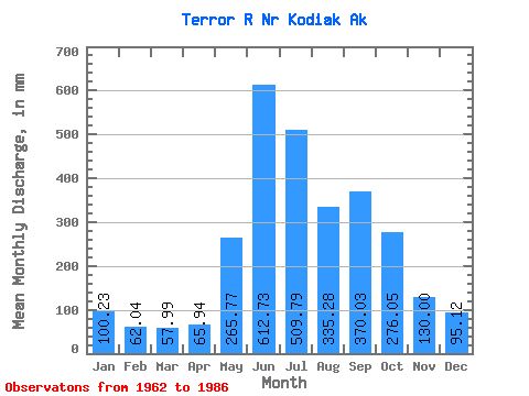
| Statistic | Jan | Feb | Mar | Apr | May | Jun | Jul | Aug | Sep | Oct | Nov | Dec | Annual |
|---|---|---|---|---|---|---|---|---|---|---|---|---|---|
| Mean | 100.21 | 62.60 | 57.98 | 65.92 | 265.73 | 612.75 | 509.74 | 335.20 | 370.06 | 276.04 | 129.98 | 95.08 | 2940.05 |
| Standard Deviation | 106.22 | 39.80 | 32.49 | 45.19 | 165.15 | 345.30 | 306.06 | 170.71 | 145.50 | 176.01 | 80.08 | 77.31 | 903.55 |
| Min | 30.95 | 20.08 | 17.97 | 25.16 | 35.97 | 1.02 | 1.59 | 41.41 | 153.42 | 105.29 | 43.82 | 31.14 | 1205.43 |
| Max | 421.72 | 136.38 | 116.32 | 187.09 | 557.77 | 1018.16 | 1016.61 | 627.38 | 629.74 | 746.91 | 316.67 | 279.79 | 4255.64 |
| Coefficient of Variation | 1.06 | 0.64 | 0.56 | 0.69 | 0.62 | 0.56 | 0.60 | 0.51 | 0.39 | 0.64 | 0.62 | 0.81 | 0.31 |
 Return to R-Arctic Net Home Page