|
|
|||||||||||||||||
| Point ID: 9480 | Downloads | Plots | Site Data | Code: 15294350 |
|
|
|||||||||||||||||
| Download | |
|---|---|
| Site Descriptor Information | Site Time Series Data |
| Link to all available data | |
|
|
| View: | Statistics | Time Series |
| Units: | mm |
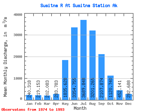
| Statistic | Jan | Feb | Mar | Apr | May | Jun | Jul | Aug | Sep | Oct | Nov | Dec | Annual |
|---|---|---|---|---|---|---|---|---|---|---|---|---|---|
| Mean | 240.32 | 219.15 | 202.08 | 283.78 | 1835.63 | 3354.76 | 3689.85 | 3201.26 | 2107.87 | 1120.74 | 452.14 | 282.69 | 1419.18 |
| Standard Deviation | 36.94 | 30.38 | 35.91 | 130.91 | 535.32 | 553.57 | 522.82 | 559.48 | 594.52 | 447.36 | 137.87 | 65.42 | 164.87 |
| Min | 176.75 | 158.97 | 152.00 | 164.71 | 1272.43 | 2574.95 | 2925.22 | 2468.77 | 1110.96 | 531.63 | 281.28 | 169.90 | 1187.55 |
| Max | 302.81 | 275.94 | 274.49 | 608.34 | 3425.43 | 4697.76 | 5135.40 | 4518.82 | 3275.03 | 2506.04 | 894.62 | 415.89 | 1647.46 |
| Coefficient of Variation | 0.15 | 0.14 | 0.18 | 0.46 | 0.29 | 0.17 | 0.14 | 0.17 | 0.28 | 0.40 | 0.30 | 0.23 | 0.12 |
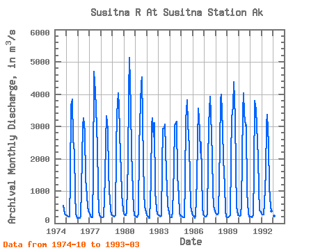
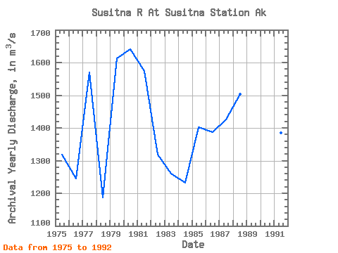
| Year | Jan | Feb | Mar | Apr | May | Jun | Jul | Aug | Sep | Oct | Nov | Dec | Annual | 1974 | 552.63 | 294.50 | 266.73 | 1975 | 243.43 | 220.97 | 199.59 | 194.44 | 1346.15 | 3646.27 | 3842.87 | 2587.16 | 2201.26 | 893.35 | 281.28 | 169.90 | 1318.89 | 1976 | 184.88 | 158.97 | 152.00 | 205.39 | 1995.15 | 3029.90 | 3262.92 | 2821.73 | 1384.98 | 853.43 | 517.25 | 370.86 | 1244.79 | 1977 | 285.91 | 252.32 | 191.82 | 176.51 | 1590.86 | 4697.76 | 4074.89 | 3553.58 | 2373.24 | 1082.53 | 357.74 | 213.20 | 1570.86 | 1978 | 197.49 | 191.75 | 186.62 | 199.16 | 1378.30 | 2574.95 | 3329.51 | 2890.78 | 1571.49 | 1042.24 | 424.75 | 263.53 | 1187.55 | 1979 | 249.83 | 225.02 | 199.13 | 245.88 | 2301.06 | 3395.19 | 4033.78 | 3630.49 | 2105.07 | 1660.55 | 894.62 | 415.89 | 1613.04 | 1980 | 286.55 | 255.34 | 252.20 | 340.65 | 1885.45 | 4046.48 | 5135.40 | 3578.88 | 2207.77 | 990.27 | 458.73 | 241.15 | 1639.91 | 1981 | 220.14 | 214.91 | 174.93 | 293.08 | 2366.74 | 3076.81 | 4327.45 | 4518.82 | 1902.04 | 959.85 | 497.43 | 332.49 | 1573.72 | 1982 | 255.76 | 204.29 | 153.92 | 164.71 | 1272.43 | 3061.81 | 3250.50 | 2679.60 | 3105.41 | 963.14 | 430.42 | 280.06 | 1318.50 | 1983 | 236.95 | 238.47 | 201.69 | 217.49 | 1758.29 | 2941.18 | 2925.22 | 3056.76 | 1553.75 | 1116.87 | 538.96 | 325.19 | 1259.23 | 1984 | 210.55 | 189.82 | 183.15 | 368.59 | 1711.25 | 3031.60 | 3092.29 | 3142.26 | 1444.44 | 871.43 | 310.07 | 232.93 | 1232.36 | 1985 | 225.62 | 196.70 | 184.06 | 193.03 | 1293.08 | 3191.12 | 3813.64 | 3079.23 | 2381.82 | 1435.48 | 521.97 | 315.14 | 1402.58 | 1986 | 251.20 | 219.46 | 169.17 | 203.69 | 1347.70 | 2576.83 | 3549.75 | 2880.10 | 2179.93 | 2506.04 | 495.55 | 264.62 | 1387.00 | 1987 | 220.69 | 212.38 | 208.08 | 279.20 | 1850.92 | 3073.51 | 3930.56 | 3394.09 | 2081.48 | 973.28 | 540.38 | 353.50 | 1426.51 | 1988 | 302.81 | 275.94 | 269.01 | 314.98 | 2366.56 | 3847.32 | 3982.63 | 2922.57 | 1994.36 | 1173.50 | 391.72 | 198.22 | 1503.30 | 1989 | 176.75 | 176.47 | 198.22 | 252.02 | 1991.77 | 3270.22 | 3598.07 | 4378.15 | 3275.03 | 1673.98 | 528.58 | 250.28 | 1647.46 | 1990 | 236.95 | 232.50 | 256.50 | 606.92 | 3425.43 | 4032.32 | 3379.94 | 3026.80 | 3039.81 | 953.27 | 322.34 | 212.38 | 1643.76 | 1991 | 212.38 | 211.67 | 185.89 | 244.00 | 1599.45 | 3801.06 | 3513.85 | 3013.00 | 2028.90 | 1060.60 | 397.38 | 346.20 | 1384.53 | 1992 | 300.07 | 269.01 | 274.49 | 608.34 | 1560.71 | 3091.26 | 3374.00 | 2468.77 | 1110.96 | 531.63 | 387.00 | 318.79 | 1191.25 | 1993 | 268.10 | 217.94 | 199.13 |
|---|
 Return to R-Arctic Net Home Page