|
|
|||||||||||||||||
| Point ID: 9463 | Downloads | Plots | Site Data | Code: 15239880 |
|
|
|||||||||||||||||
| Download | |
|---|---|
| Site Descriptor Information | Site Time Series Data |
| Link to all available data | |
|
|
| View: | Statistics | Time Series |
| Units: | mm |
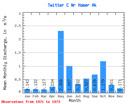
| Statistic | Jan | Feb | Mar | Apr | May | Jun | Jul | Aug | Sep | Oct | Nov | Dec | Annual |
|---|---|---|---|---|---|---|---|---|---|---|---|---|---|
| Mean | 0.14 | 0.13 | 0.13 | 0.23 | 2.31 | 1.01 | 0.33 | 0.53 | 0.68 | 1.18 | 0.30 | 0.17 | 0.61 |
| Standard Deviation | 0.02 | 0.01 | 0.01 | 0.15 | 0.22 | 0.13 | 0.01 | 0.15 | 0.39 | 0.04 | 0.02 | 0.02 | |
| Min | 0.13 | 0.12 | 0.12 | 0.13 | 2.15 | 0.92 | 0.33 | 0.42 | 0.43 | 1.15 | 0.29 | 0.15 | 0.61 |
| Max | 0.16 | 0.14 | 0.13 | 0.34 | 2.46 | 1.10 | 0.34 | 0.70 | 1.12 | 1.21 | 0.32 | 0.19 | 0.61 |
| Coefficient of Variation | 0.13 | 0.11 | 0.09 | 0.62 | 0.10 | 0.13 | 0.01 | 0.28 | 0.57 | 0.04 | 0.07 | 0.13 |
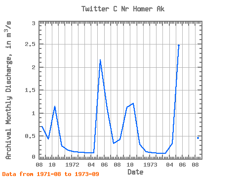
| Year | Jan | Feb | Mar | Apr | May | Jun | Jul | Aug | Sep | Oct | Nov | Dec | Annual | 1971 | 0.70 | 0.43 | 1.15 | 0.29 | 0.19 | 1972 | 0.16 | 0.14 | 0.13 | 0.13 | 2.15 | 1.10 | 0.34 | 0.42 | 1.12 | 1.21 | 0.32 | 0.15 | 0.61 | 1973 | 0.13 | 0.12 | 0.12 | 0.34 | 2.46 | 0.92 | 0.33 | 0.46 | 0.48 |
|---|
 Return to R-Arctic Net Home Page