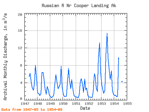
| Point ID: 9443 | Downloads | Plots | Site Data | Code: 15264000 |
| Download | |
|---|---|
| Site Descriptor Information | Site Time Series Data |
| Link to all available data | |

|

|
| View: | Statistics | Time Series |
| Units: | mm |
| Statistic | Jan | Feb | Mar | Apr | May | Jun | Jul | Aug | Sep | Oct | Nov | Dec | Annual |
|---|---|---|---|---|---|---|---|---|---|---|---|---|---|
| Mean | 1.38 | 1.09 | 0.85 | 1.19 | 5.58 | 7.43 | 5.06 | 3.27 | 3.15 | 4.58 | 5.34 | 2.69 | 3.42 |
| Standard Deviation | 1.00 | 0.66 | 0.34 | 0.56 | 2.98 | 3.31 | 2.00 | 1.57 | 1.40 | 2.75 | 4.42 | 2.25 | 1.23 |
| Min | 0.68 | 0.56 | 0.51 | 0.58 | 1.76 | 4.92 | 3.46 | 1.78 | 1.33 | 2.38 | 1.14 | 0.76 | 2.37 |
| Max | 3.48 | 2.40 | 1.55 | 2.32 | 10.13 | 15.37 | 9.82 | 6.76 | 4.80 | 9.88 | 13.16 | 6.54 | 5.58 |
| Coefficient of Variation | 0.72 | 0.61 | 0.40 | 0.47 | 0.53 | 0.45 | 0.40 | 0.48 | 0.44 | 0.60 | 0.83 | 0.83 | 0.36 |
| Year | Jan | Feb | Mar | Apr | May | Jun | Jul | Aug | Sep | Oct | Nov | Dec | Annual | 1947 | 5.41 | 6.12 | 3.90 | 2.78 | 2.27 | 3.88 | 7.96 | 4.87 | 1948 | 1.70 | 1.45 | 1.01 | 1.45 | 6.32 | 6.34 | 4.70 | 2.59 | 1.33 | 3.12 | 2.28 | 1.14 | 2.79 | 1949 | 0.72 | 0.56 | 0.74 | 1.02 | 3.28 | 5.82 | 4.41 | 2.63 | 2.94 | 3.71 | 7.79 | 3.12 | 3.06 | 1950 | 1.29 | 0.86 | 0.81 | 0.87 | 3.82 | 7.25 | 4.45 | 2.62 | 4.72 | 2.38 | 1.14 | 0.76 | 2.58 | 1951 | 0.72 | 0.60 | 0.51 | 1.14 | 4.33 | 4.92 | 3.46 | 1.78 | 4.80 | 2.40 | 2.79 | 1.03 | 2.37 | 1952 | 0.68 | 0.65 | 0.62 | 0.58 | 1.76 | 6.05 | 5.34 | 2.74 | 1.98 | 9.88 | 13.16 | 6.54 | 4.16 | 1953 | 3.48 | 2.40 | 1.55 | 2.32 | 10.13 | 15.37 | 9.82 | 6.76 | 4.74 | 6.68 | 2.26 | 1.39 | 5.58 | 1954 | 1.06 | 1.09 | 0.74 | 0.93 | 9.62 | 7.57 | 4.40 | 4.25 | 2.44 |
|---|
 Return to R-Arctic Net Home Page