|
|
|||||||||||||||||
| Point ID: 9428 | Downloads | Plots | Site Data | Code: 15565235 |
|
|
|||||||||||||||||
| Download | |
|---|---|
| Site Descriptor Information | Site Time Series Data |
| Link to all available data | |
|
|
| View: | Statistics | Time Series |
| Units: | mm |
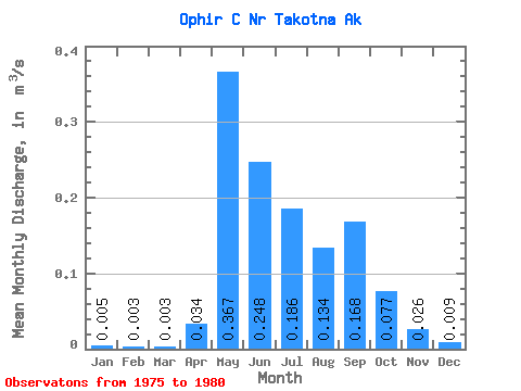
| Statistic | Jan | Feb | Mar | Apr | May | Jun | Jul | Aug | Sep | Oct | Nov | Dec | Annual |
|---|---|---|---|---|---|---|---|---|---|---|---|---|---|
| Mean | 0.01 | 0.00 | 0.00 | 0.03 | 0.37 | 0.25 | 0.19 | 0.13 | 0.17 | 0.08 | 0.03 | 0.01 | 0.10 |
| Standard Deviation | 0.01 | 0.01 | 0.01 | 0.03 | 0.30 | 0.09 | 0.10 | 0.08 | 0.07 | 0.04 | 0.02 | 0.01 | 0.03 |
| Min | 0.00 | 0.00 | 0.00 | 0.00 | 0.07 | 0.17 | 0.06 | 0.04 | 0.04 | 0.02 | 0.01 | 0.00 | 0.06 |
| Max | 0.02 | 0.01 | 0.01 | 0.07 | 0.87 | 0.40 | 0.30 | 0.27 | 0.24 | 0.12 | 0.06 | 0.02 | 0.14 |
| Coefficient of Variation | 1.27 | 1.73 | 1.78 | 0.83 | 0.82 | 0.36 | 0.51 | 0.62 | 0.44 | 0.53 | 0.81 | 0.85 | 0.34 |
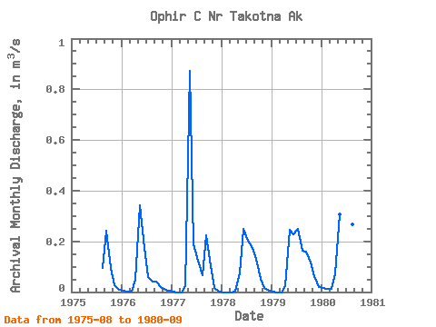
| Year | Jan | Feb | Mar | Apr | May | Jun | Jul | Aug | Sep | Oct | Nov | Dec | Annual | 1975 | 0.09 | 0.24 | 0.09 | 0.03 | 0.01 | 1976 | 0.01 | 0.00 | 0.00 | 0.05 | 0.34 | 0.17 | 0.06 | 0.04 | 0.04 | 0.02 | 0.01 | 0.00 | 0.06 | 1977 | 0.00 | 0.00 | 0.00 | 0.02 | 0.87 | 0.19 | 0.12 | 0.07 | 0.22 | 0.10 | 0.01 | 0.00 | 0.14 | 1978 | 0.00 | 0.00 | 0.00 | 0.00 | 0.07 | 0.25 | 0.20 | 0.17 | 0.13 | 0.05 | 0.02 | 0.01 | 0.07 | 1979 | 0.00 | 0.00 | 0.00 | 0.03 | 0.25 | 0.23 | 0.25 | 0.16 | 0.16 | 0.12 | 0.06 | 0.02 | 0.11 | 1980 | 0.02 | 0.01 | 0.01 | 0.07 | 0.31 | 0.40 | 0.30 | 0.27 | 0.20 |
|---|
 Return to R-Arctic Net Home Page