|
|
|||||||||||||||||
| Point ID: 9380 | Downloads | Plots | Site Data | Code: 15300500 |
|
|
|||||||||||||||||
| Download | |
|---|---|
| Site Descriptor Information | Site Time Series Data |
| Link to all available data | |
|
|
| View: | Statistics | Time Series |
| Units: | mm |
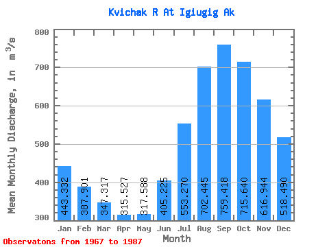
| Statistic | Jan | Feb | Mar | Apr | May | Jun | Jul | Aug | Sep | Oct | Nov | Dec | Annual |
|---|---|---|---|---|---|---|---|---|---|---|---|---|---|
| Mean | 443.33 | 387.90 | 347.32 | 315.53 | 317.59 | 405.23 | 553.27 | 702.45 | 759.42 | 715.64 | 616.94 | 518.49 | 498.96 |
| Standard Deviation | 89.67 | 85.49 | 102.33 | 97.42 | 77.91 | 82.43 | 116.23 | 189.25 | 213.44 | 193.21 | 157.57 | 115.52 | 102.41 |
| Min | 275.40 | 230.58 | 200.04 | 190.86 | 208.72 | 304.41 | 383.83 | 431.79 | 488.09 | 469.51 | 395.49 | 330.67 | 354.70 |
| Max | 586.52 | 537.01 | 660.88 | 624.76 | 510.62 | 550.76 | 793.33 | 1141.90 | 1220.27 | 1094.13 | 961.45 | 761.27 | 725.12 |
| Coefficient of Variation | 0.20 | 0.22 | 0.29 | 0.31 | 0.24 | 0.20 | 0.21 | 0.27 | 0.28 | 0.27 | 0.26 | 0.22 | 0.20 |
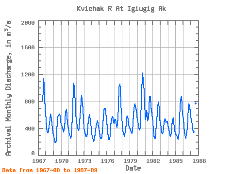
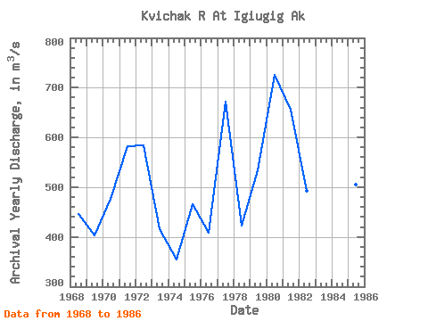
| Year | Jan | Feb | Mar | Apr | May | Jun | Jul | Aug | Sep | Oct | Nov | Dec | Annual | 1967 | 812.05 | 1143.06 | 1034.94 | 843.84 | 689.65 | 1968 | 531.81 | 414.60 | 344.37 | 335.65 | 371.32 | 428.72 | 532.54 | 613.47 | 588.61 | 469.51 | 395.49 | 330.67 | 446.40 | 1969 | 275.40 | 230.58 | 200.04 | 190.86 | 208.72 | 334.61 | 526.14 | 598.31 | 586.16 | 610.91 | 587.86 | 495.09 | 403.72 | 1970 | 453.07 | 424.75 | 395.98 | 370.38 | 344.37 | 422.11 | 524.50 | 643.89 | 686.40 | 582.69 | 467.23 | 397.35 | 476.06 | 1971 | 340.71 | 311.49 | 278.73 | 255.27 | 294.59 | 423.81 | 673.85 | 1023.61 | 1068.30 | 931.35 | 774.94 | 601.96 | 581.55 | 1972 | 494.18 | 430.61 | 396.44 | 368.12 | 397.35 | 506.12 | 670.93 | 801.09 | 894.62 | 824.48 | 693.38 | 525.69 | 583.58 | 1973 | 405.57 | 343.24 | 307.74 | 277.69 | 275.37 | 332.25 | 446.31 | 537.11 | 606.92 | 578.58 | 467.89 | 399.36 | 414.84 | 1974 | 323.82 | 270.53 | 231.10 | 201.99 | 239.56 | 311.01 | 383.83 | 431.79 | 488.09 | 510.16 | 463.92 | 400.55 | 354.70 | 1975 | 345.74 | 286.71 | 254.85 | 254.85 | 272.39 | 372.84 | 565.70 | 661.79 | 697.35 | 692.85 | 638.07 | 540.76 | 465.32 | 1976 | 423.84 | 340.78 | 268.10 | 237.50 | 234.30 | 304.41 | 449.32 | 531.44 | 568.13 | 578.94 | 487.90 | 467.14 | 407.65 | 1977 | 525.23 | 531.95 | 486.87 | 438.82 | 411.60 | 546.14 | 738.07 | 1016.85 | 1055.56 | 987.07 | 745.49 | 569.99 | 671.14 | 1978 | 446.68 | 363.06 | 319.71 | 279.73 | 289.66 | 360.76 | 448.69 | 560.86 | 581.63 | 544.60 | 457.60 | 419.82 | 422.73 | 1979 | 399.08 | 375.70 | 351.22 | 327.72 | 374.24 | 468.17 | 619.50 | 751.04 | 764.46 | 719.89 | 661.29 | 597.12 | 534.12 | 1980 | 520.30 | 466.15 | 406.48 | 378.22 | 412.24 | 545.67 | 793.33 | 1141.90 | 1220.27 | 1094.13 | 961.45 | 761.27 | 725.12 | 1981 | 586.52 | 537.01 | 660.88 | 624.76 | 510.62 | 550.76 | 700.07 | 878.28 | 870.08 | 724.91 | 664.41 | 554.37 | 655.22 | 1982 | 481.94 | 389.36 | 291.48 | 251.83 | 255.31 | 362.93 | 513.36 | 632.56 | 738.60 | 792.23 | 673.19 | 537.20 | 493.33 | 1983 | 461.56 | 405.33 | 344.28 | 317.05 | 340.44 | 411.25 | 485.86 | 541.86 | 521.41 | 491.89 | 500.55 | 508.88 | 444.20 | 1984 | 437.36 | 386.38 | 338.71 | 299.37 | 282.22 | 324.70 | 434.44 | 513.63 | 558.98 | 497.65 | 397.85 | 331.31 | 400.21 | 1985 | 311.49 | 299.86 | 286.64 | 254.26 | 236.79 | 341.09 | 553.37 | 730.94 | 823.83 | 880.93 | 735.86 | 609.54 | 505.38 | 1986 | 538.48 | 435.98 | 341.26 | 266.18 | 253.94 | 320.33 | 399.82 | 558.48 | 707.73 | 765.10 | 720.66 | 632.11 | 495.00 | 1987 | 563.87 | 513.95 | 441.47 | 380.30 | 346.74 | 436.83 | 605.80 | 770.40 | 777.58 |
|---|
 Return to R-Arctic Net Home Page