|
|
|||||||||||||||||
| Point ID: 9376 | Downloads | Plots | Site Data | Code: 15298000 |
|
|
|||||||||||||||||
| Download | |
|---|---|
| Site Descriptor Information | Site Time Series Data |
| Link to all available data | |
| View: | Time Series | All |
| Units: | m3/s |
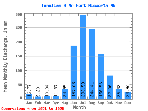
| Statistic | Jan | Feb | Mar | Apr | May | Jun | Jul | Aug | Sep | Oct | Nov | Dec | Annual |
|---|---|---|---|---|---|---|---|---|---|---|---|---|---|
| Mean | 16.76 | 9.28 | 10.04 | 11.37 | 34.95 | 187.04 | 293.54 | 244.38 | 156.56 | 82.05 | 36.33 | 23.90 | 1126.26 |
| Standard Deviation | 8.56 | 2.91 | 3.61 | 5.22 | 23.40 | 87.36 | 63.44 | 29.38 | 37.47 | 40.16 | 14.69 | 10.23 | 188.22 |
| Min | 8.93 | 6.34 | 7.03 | 8.17 | 13.10 | 139.60 | 192.15 | 217.42 | 107.32 | 43.29 | 20.98 | 14.64 | 980.60 |
| Max | 26.35 | 12.35 | 15.40 | 20.55 | 69.95 | 342.99 | 362.07 | 293.21 | 211.83 | 149.89 | 54.01 | 40.33 | 1398.90 |
| Coefficient of Variation | 0.51 | 0.31 | 0.36 | 0.46 | 0.67 | 0.47 | 0.22 | 0.12 | 0.24 | 0.49 | 0.40 | 0.43 | 0.17 |
 Return to R-Arctic Net Home Page