|
|
|||||||||||||||||
| Point ID: 9371 | Downloads | Plots | Site Data | Code: 15297690 |
|
|
|||||||||||||||||
| Download | |
|---|---|
| Site Descriptor Information | Site Time Series Data |
| Link to all available data | |
| View: | Time Series | All |
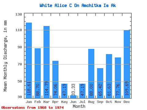
| Units: | m3/s |
| Statistic | Jan | Feb | Mar | Apr | May | Jun | Jul | Aug | Sep | Oct | Nov | Dec | Annual |
|---|---|---|---|---|---|---|---|---|---|---|---|---|---|
| Mean | 118.93 | 89.51 | 114.74 | 73.76 | 47.24 | 33.67 | 47.73 | 88.45 | 64.91 | 82.14 | 77.99 | 110.01 | 926.07 |
| Standard Deviation | 62.07 | 44.64 | 65.88 | 40.36 | 28.93 | 18.60 | 24.19 | 58.96 | 32.01 | 43.30 | 44.33 | 82.09 | 473.05 |
| Min | 9.75 | 4.13 | 3.13 | 1.85 | 1.60 | 1.23 | 5.10 | 2.10 | 4.28 | 2.02 | 5.35 | 5.35 | 93.82 |
| Max | 183.84 | 128.39 | 191.41 | 117.67 | 92.11 | 57.64 | 81.61 | 169.81 | 86.28 | 123.70 | 112.20 | 226.21 | 1279.30 |
| Coefficient of Variation | 0.52 | 0.50 | 0.57 | 0.55 | 0.61 | 0.55 | 0.51 | 0.67 | 0.49 | 0.53 | 0.57 | 0.75 | 0.51 |
 Return to R-Arctic Net Home Page