|
|
|||||||||||||||||
| Point ID: 9371 | Downloads | Plots | Site Data | Code: 15297690 |
|
|
|||||||||||||||||
| Download | |
|---|---|
| Site Descriptor Information | Site Time Series Data |
| Link to all available data | |
|
|
| View: | Statistics | Time Series |
| Units: | mm |
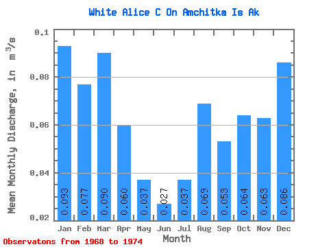
| Statistic | Jan | Feb | Mar | Apr | May | Jun | Jul | Aug | Sep | Oct | Nov | Dec | Annual |
|---|---|---|---|---|---|---|---|---|---|---|---|---|---|
| Mean | 0.09 | 0.08 | 0.09 | 0.06 | 0.04 | 0.03 | 0.04 | 0.07 | 0.05 | 0.06 | 0.06 | 0.09 | 0.06 |
| Standard Deviation | 0.05 | 0.04 | 0.05 | 0.03 | 0.02 | 0.01 | 0.02 | 0.05 | 0.03 | 0.03 | 0.04 | 0.06 | 0.03 |
| Min | 0.01 | 0.00 | 0.00 | 0.00 | 0.00 | 0.00 | 0.00 | 0.00 | 0.00 | 0.00 | 0.00 | 0.00 | 0.01 |
| Max | 0.14 | 0.11 | 0.15 | 0.10 | 0.07 | 0.05 | 0.06 | 0.13 | 0.07 | 0.10 | 0.09 | 0.18 | 0.09 |
| Coefficient of Variation | 0.52 | 0.50 | 0.57 | 0.55 | 0.61 | 0.55 | 0.51 | 0.67 | 0.49 | 0.53 | 0.57 | 0.75 | 0.51 |
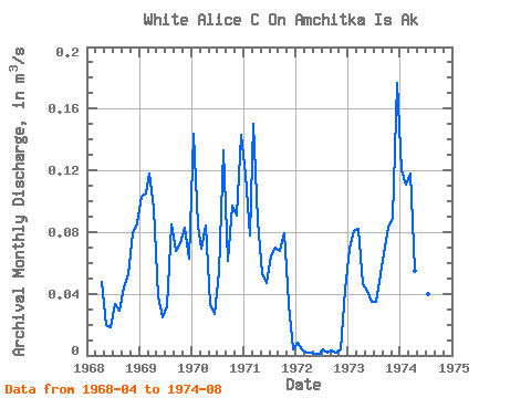
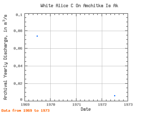
| Year | Jan | Feb | Mar | Apr | May | Jun | Jul | Aug | Sep | Oct | Nov | Dec | Annual | 1968 | 0.05 | 0.02 | 0.02 | 0.03 | 0.03 | 0.04 | 0.05 | 0.08 | 0.09 | 1969 | 0.10 | 0.10 | 0.12 | 0.10 | 0.04 | 0.03 | 0.03 | 0.09 | 0.07 | 0.07 | 0.08 | 0.06 | 0.07 | 1970 | 0.14 | 0.08 | 0.07 | 0.08 | 0.03 | 0.03 | 0.05 | 0.13 | 0.06 | 0.10 | 0.09 | 0.14 | 0.09 | 1971 | 0.12 | 0.08 | 0.15 | 0.09 | 0.05 | 0.05 | 0.06 | 0.07 | 0.07 | 0.08 | 0.03 | 0.00 | 0.07 | 1972 | 0.01 | 0.00 | 0.00 | 0.00 | 0.00 | 0.00 | 0.00 | 0.00 | 0.00 | 0.00 | 0.00 | 0.04 | 0.01 | 1973 | 0.07 | 0.08 | 0.08 | 0.05 | 0.04 | 0.04 | 0.04 | 0.05 | 0.07 | 0.08 | 0.09 | 0.18 | 0.07 | 1974 | 0.12 | 0.11 | 0.12 | 0.06 | 0.07 | 0.04 | 0.04 | 0.11 |
|---|
 Return to R-Arctic Net Home Page