|
|
|||||||||||||||||
| Point ID: 9356 | Downloads | Plots | Site Data | Code: 15476400 |
|
|
|||||||||||||||||
| Download | |
|---|---|
| Site Descriptor Information | Site Time Series Data |
| Link to all available data | |
|
|
| View: | Statistics | Time Series |
| Units: | mm |
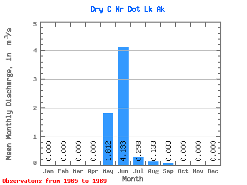
| Statistic | Jan | Feb | Mar | Apr | May | Jun | Jul | Aug | Sep | Oct | Nov | Dec | Annual |
|---|---|---|---|---|---|---|---|---|---|---|---|---|---|
| Mean | 0.00 | 0.00 | 0.00 | 0.00 | 1.81 | 4.13 | 0.30 | 0.13 | 0.08 | 0.00 | 0.00 | 0.00 | 0.65 |
| Standard Deviation | 0.00 | 0.00 | 0.00 | 0.00 | 1.13 | 2.86 | 0.46 | 0.26 | 0.14 | 0.00 | 0.00 | 0.00 | 0.15 |
| Min | 0.00 | 0.00 | 0.00 | 0.00 | 0.76 | 0.01 | 0.00 | 0.00 | 0.00 | 0.00 | 0.00 | 0.00 | 0.54 |
| Max | 0.00 | 0.00 | 0.00 | 0.00 | 3.41 | 6.23 | 0.98 | 0.53 | 0.29 | 0.00 | 0.00 | 0.00 | 0.82 |
| Coefficient of Variation | 0.62 | 0.69 | 1.55 | 1.97 | 1.70 | 0.24 |
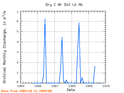
| Year | Jan | Feb | Mar | Apr | May | Jun | Jul | Aug | Sep | Oct | Nov | Dec | Annual | 1965 | 0.00 | 0.00 | 0.00 | 1966 | 0.00 | 0.00 | 0.00 | 0.00 | 0.76 | 6.23 | 0.00 | 0.00 | 0.00 | 0.00 | 0.00 | 0.00 | 0.58 | 1967 | 0.00 | 0.00 | 0.00 | 0.00 | 1.53 | 4.44 | 0.19 | 0.01 | 0.29 | 0.00 | 0.00 | 0.00 | 0.54 | 1968 | 0.00 | 0.00 | 0.00 | 0.00 | 3.41 | 5.86 | 0.03 | 0.53 | 0.04 | 0.00 | 0.00 | 0.00 | 0.82 | 1969 | 0.00 | 0.00 | 0.00 | 0.00 | 1.56 | 0.01 | 0.98 | 0.00 | 0.00 |
|---|
 Return to R-Arctic Net Home Page