|
|
|||||||||||||||||
| Point ID: 9349 | Downloads | Plots | Site Data | Code: 15320100 |
|
|
|||||||||||||||||
| Download | |
|---|---|
| Site Descriptor Information | Site Time Series Data |
| Link to all available data | |
| View: | Time Series | All |
| Units: | m3/s |
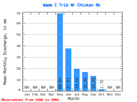
| Statistic | Jan | Feb | Mar | Apr | May | Jun | Jul | Aug | Sep | Oct | Nov | Dec | Annual |
|---|---|---|---|---|---|---|---|---|---|---|---|---|---|
| Mean | 68.70 | 37.80 | 19.57 | 16.96 | 13.39 | 1.74 | |||||||
| Standard Deviation | 53.31 | 25.76 | 21.33 | 10.55 | 8.86 | 1.05 | |||||||
| Min | 10.28 | 5.32 | 1.47 | 1.11 | 0.62 | 0.62 | |||||||
| Max | 157.93 | 77.24 | 56.75 | 28.71 | 25.92 | 2.71 | |||||||
| Coefficient of Variation | 0.78 | 0.68 | 1.09 | 0.62 | 0.66 | 0.61 |
 Return to R-Arctic Net Home Page