|
|
|||||||||||||||||
| Point ID: 9341 | Downloads | Plots | Site Data | Code: 15303100 |
|
|
|||||||||||||||||
| Download | |
|---|---|
| Site Descriptor Information | Site Time Series Data |
| Link to all available data | |
|
|
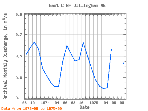
| View: | Statistics | Time Series |
| Units: | mm |
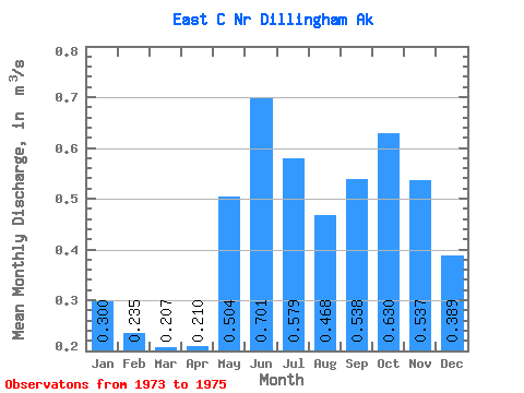
| Statistic | Jan | Feb | Mar | Apr | May | Jun | Jul | Aug | Sep | Oct | Nov | Dec | Annual |
|---|---|---|---|---|---|---|---|---|---|---|---|---|---|
| Mean | 0.30 | 0.23 | 0.21 | 0.21 | 0.50 | 0.70 | 0.58 | 0.47 | 0.54 | 0.63 | 0.54 | 0.39 | 0.42 |
| Standard Deviation | 0.03 | 0.02 | 0.01 | 0.01 | 0.08 | 0.15 | 0.08 | 0.04 | 0.06 | 0.00 | 0.04 | 0.01 | |
| Min | 0.28 | 0.22 | 0.20 | 0.20 | 0.45 | 0.60 | 0.52 | 0.43 | 0.47 | 0.63 | 0.51 | 0.38 | 0.42 |
| Max | 0.32 | 0.25 | 0.22 | 0.22 | 0.56 | 0.80 | 0.64 | 0.52 | 0.58 | 0.63 | 0.56 | 0.40 | 0.42 |
| Coefficient of Variation | 0.08 | 0.10 | 0.06 | 0.04 | 0.16 | 0.21 | 0.14 | 0.09 | 0.11 | 0.01 | 0.07 | 0.02 |
| Year | Jan | Feb | Mar | Apr | May | Jun | Jul | Aug | Sep | Oct | Nov | Dec | Annual | 1973 | 0.52 | 0.58 | 0.63 | 0.56 | 0.38 | 1974 | 0.32 | 0.25 | 0.22 | 0.22 | 0.45 | 0.60 | 0.52 | 0.46 | 0.47 | 0.63 | 0.51 | 0.40 | 0.42 | 1975 | 0.28 | 0.22 | 0.20 | 0.20 | 0.56 | 0.80 | 0.64 | 0.43 | 0.57 |
|---|
 Return to R-Arctic Net Home Page