|
|
|||||||||||||||||
| Point ID: 9334 | Downloads | Plots | Site Data | Code: 15304200 |
|
|
|||||||||||||||||
| Download | |
|---|---|
| Site Descriptor Information | Site Time Series Data |
| Link to all available data | |
| View: | Time Series | All |
| Units: | m3/s |
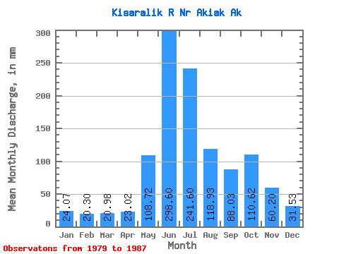
| Statistic | Jan | Feb | Mar | Apr | May | Jun | Jul | Aug | Sep | Oct | Nov | Dec | Annual |
|---|---|---|---|---|---|---|---|---|---|---|---|---|---|
| Mean | 24.06 | 20.48 | 20.97 | 23.02 | 108.71 | 298.60 | 241.56 | 118.91 | 88.03 | 110.60 | 60.20 | 31.52 | 1080.21 |
| Standard Deviation | 6.81 | 4.79 | 4.17 | 7.99 | 54.31 | 67.47 | 67.96 | 38.72 | 28.87 | 78.41 | 66.16 | 20.79 | 263.76 |
| Min | 14.08 | 12.59 | 13.35 | 13.39 | 48.76 | 165.52 | 149.66 | 61.47 | 46.56 | 51.14 | 17.45 | 14.36 | 665.32 |
| Max | 33.33 | 27.58 | 25.77 | 35.47 | 211.94 | 367.08 | 354.19 | 166.56 | 131.17 | 288.00 | 216.03 | 78.81 | 1481.65 |
| Coefficient of Variation | 0.28 | 0.23 | 0.20 | 0.35 | 0.50 | 0.23 | 0.28 | 0.33 | 0.33 | 0.71 | 1.10 | 0.66 | 0.24 |
 Return to R-Arctic Net Home Page