|
|
|||||||||||||||||
| Point ID: 9329 | Downloads | Plots | Site Data | Code: 15067900 |
|
|
|||||||||||||||||
| Download | |
|---|---|
| Site Descriptor Information | Site Time Series Data |
| Link to all available data | |
| View: | Time Series | All |
| Units: | m3/s |
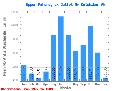
| Statistic | Jan | Feb | Mar | Apr | May | Jun | Jul | Aug | Sep | Oct | Nov | Dec | Annual |
|---|---|---|---|---|---|---|---|---|---|---|---|---|---|
| Mean | 430.99 | 311.99 | 240.60 | 337.06 | 859.35 | 1121.07 | 859.45 | 622.95 | 716.26 | 981.79 | 606.65 | 251.55 | 7551.10 |
| Standard Deviation | 374.28 | 195.64 | 194.68 | 117.00 | 222.19 | 330.87 | 294.95 | 271.36 | 320.81 | 383.25 | 411.87 | 177.57 | 1363.06 |
| Min | 35.29 | 27.73 | 34.02 | 162.66 | 422.92 | 501.09 | 354.32 | 214.37 | 391.76 | 457.70 | 114.40 | 25.10 | 5401.70 |
| Max | 1343.43 | 604.16 | 792.72 | 533.12 | 1207.06 | 1733.32 | 1248.88 | 1106.90 | 1389.86 | 1711.83 | 1411.13 | 534.67 | 9743.72 |
| Coefficient of Variation | 0.87 | 0.63 | 0.81 | 0.35 | 0.26 | 0.29 | 0.34 | 0.44 | 0.45 | 0.39 | 0.68 | 0.71 | 0.18 |
 Return to R-Arctic Net Home Page