|
|
|||||||||||||||||
| Point ID: 9326 | Downloads | Plots | Site Data | Code: 15062000 |
|
|
|||||||||||||||||
| Download | |
|---|---|
| Site Descriptor Information | Site Time Series Data |
| Link to all available data | |
| View: | Time Series | All |
| Units: | m3/s |
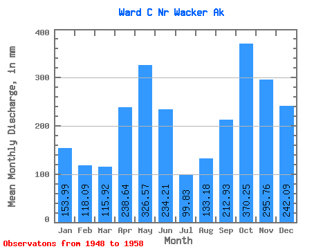
| Statistic | Jan | Feb | Mar | Apr | May | Jun | Jul | Aug | Sep | Oct | Nov | Dec | Annual |
|---|---|---|---|---|---|---|---|---|---|---|---|---|---|
| Mean | 153.97 | 119.09 | 115.94 | 238.63 | 326.49 | 234.21 | 99.80 | 133.19 | 212.94 | 370.17 | 295.74 | 242.06 | 2571.90 |
| Standard Deviation | 115.89 | 107.38 | 80.81 | 207.19 | 151.89 | 143.44 | 84.25 | 94.44 | 161.55 | 194.19 | 122.75 | 147.39 | 1136.29 |
| Min | 10.51 | 12.37 | 14.20 | 25.15 | 64.45 | 13.05 | 0.52 | 6.30 | 20.07 | 55.23 | 93.11 | 21.44 | 695.15 |
| Max | 378.53 | 355.80 | 250.71 | 648.51 | 482.43 | 433.11 | 259.98 | 307.87 | 472.60 | 751.65 | 504.14 | 457.10 | 4252.31 |
| Coefficient of Variation | 0.75 | 0.90 | 0.70 | 0.87 | 0.47 | 0.61 | 0.84 | 0.71 | 0.76 | 0.53 | 0.41 | 0.61 | 0.44 |
 Return to R-Arctic Net Home Page