|
|
|||||||||||||||||
| Point ID: 9324 | Downloads | Plots | Site Data | Code: 15059500 |
|
|
|||||||||||||||||
| Download | |
|---|---|
| Site Descriptor Information | Site Time Series Data |
| Link to all available data | |
| View: | Time Series | All |
| Units: | m3/s |
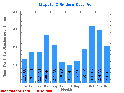
| Statistic | Jan | Feb | Mar | Apr | May | Jun | Jul | Aug | Sep | Oct | Nov | Dec | Annual |
|---|---|---|---|---|---|---|---|---|---|---|---|---|---|
| Mean | 135.86 | 172.66 | 169.22 | 265.39 | 209.45 | 115.10 | 98.13 | 123.45 | 190.06 | 318.57 | 294.42 | 206.78 | 2255.05 |
| Standard Deviation | 75.04 | 99.12 | 65.81 | 185.85 | 64.90 | 44.87 | 45.57 | 82.89 | 72.20 | 148.48 | 182.32 | 112.64 | 419.45 |
| Min | 20.89 | 39.12 | 70.33 | 86.60 | 78.60 | 28.45 | 35.19 | 22.35 | 52.60 | 164.06 | 40.93 | 86.42 | 1695.57 |
| Max | 246.47 | 320.96 | 323.40 | 764.16 | 283.38 | 175.38 | 175.93 | 286.96 | 301.62 | 614.75 | 744.51 | 416.39 | 3154.62 |
| Coefficient of Variation | 0.55 | 0.57 | 0.39 | 0.70 | 0.31 | 0.39 | 0.46 | 0.67 | 0.38 | 0.47 | 0.62 | 0.55 | 0.19 |
 Return to R-Arctic Net Home Page