|
|
|||||||||||||||||
| Point ID: 9303 | Downloads | Plots | Site Data | Code: 15085400 |
|
|
|||||||||||||||||
| Download | |
|---|---|
| Site Descriptor Information | Site Time Series Data |
| Link to all available data | |
|
|
| View: | Statistics | Time Series |
| Units: | mm |
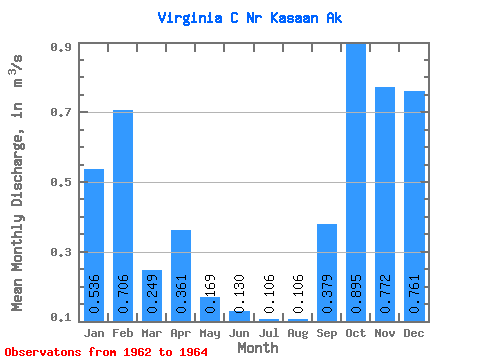
| Statistic | Jan | Feb | Mar | Apr | May | Jun | Jul | Aug | Sep | Oct | Nov | Dec | Annual |
|---|---|---|---|---|---|---|---|---|---|---|---|---|---|
| Mean | 0.54 | 0.71 | 0.25 | 0.36 | 0.17 | 0.13 | 0.11 | 0.11 | 0.38 | 0.90 | 0.77 | 0.76 | 0.42 |
| Standard Deviation | 0.29 | 0.02 | 0.09 | 0.06 | 0.09 | 0.03 | 0.04 | 0.07 | 0.07 | 0.55 | 0.15 | 0.07 | |
| Min | 0.33 | 0.69 | 0.19 | 0.32 | 0.11 | 0.11 | 0.06 | 0.03 | 0.30 | 0.51 | 0.66 | 0.71 | 0.42 |
| Max | 0.74 | 0.72 | 0.31 | 0.40 | 0.23 | 0.17 | 0.13 | 0.15 | 0.44 | 1.28 | 0.88 | 0.81 | 0.42 |
| Coefficient of Variation | 0.54 | 0.03 | 0.35 | 0.17 | 0.51 | 0.25 | 0.35 | 0.61 | 0.19 | 0.62 | 0.20 | 0.09 |
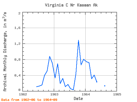
| Year | Jan | Feb | Mar | Apr | May | Jun | Jul | Aug | Sep | Oct | Nov | Dec | Annual | 1962 | 0.11 | 0.13 | 0.15 | 0.40 | 0.51 | 0.88 | 0.71 | 1963 | 0.33 | 0.69 | 0.19 | 0.32 | 0.11 | 0.17 | 0.06 | 0.03 | 0.44 | 1.28 | 0.66 | 0.81 | 0.42 | 1964 | 0.74 | 0.72 | 0.31 | 0.40 | 0.23 | 0.11 | 0.12 | 0.13 | 0.30 |
|---|
 Return to R-Arctic Net Home Page