|
|
|||||||||||||||||
| Point ID: 9294 | Downloads | Plots | Site Data | Code: 15081610 |
|
|
|||||||||||||||||
| Download | |
|---|---|
| Site Descriptor Information | Site Time Series Data |
| Link to all available data | |
|
|
| View: | Statistics | Time Series |
| Units: | mm |
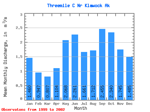
| Statistic | Jan | Feb | Mar | Apr | May | Jun | Jul | Aug | Sep | Oct | Nov | Dec | Annual |
|---|---|---|---|---|---|---|---|---|---|---|---|---|---|
| Mean | 1.46 | 0.95 | 0.81 | 1.10 | 2.07 | 2.26 | 1.66 | 1.71 | 2.46 | 2.34 | 1.75 | 1.48 | 1.54 |
| Standard Deviation | 0.48 | 0.17 | 0.32 | 0.30 | 0.38 | 0.59 | 0.24 | 0.62 | 0.72 | 0.77 | 0.16 | 0.13 | 0.18 |
| Min | 1.02 | 0.76 | 0.45 | 0.72 | 1.59 | 1.76 | 1.35 | 1.07 | 1.63 | 1.69 | 1.64 | 1.36 | 1.41 |
| Max | 1.98 | 1.09 | 1.19 | 1.42 | 2.52 | 3.05 | 1.94 | 2.56 | 3.33 | 3.19 | 1.93 | 1.62 | 1.67 |
| Coefficient of Variation | 0.33 | 0.18 | 0.40 | 0.27 | 0.18 | 0.26 | 0.14 | 0.36 | 0.29 | 0.33 | 0.09 | 0.09 | 0.12 |
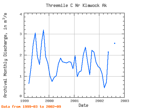
| Year | Jan | Feb | Mar | Apr | May | Jun | Jul | Aug | Sep | Oct | Nov | Dec | Annual | 1999 | 0.65 | 1.42 | 2.52 | 3.05 | 1.94 | 1.55 | 2.63 | 3.19 | 1.93 | 1.62 | 2000 | 1.02 | 0.76 | 0.94 | 1.02 | 1.59 | 1.86 | 1.69 | 1.66 | 1.63 | 1.69 | 1.67 | 1.36 | 1.41 | 2001 | 1.98 | 0.99 | 1.19 | 1.25 | 2.02 | 2.37 | 1.67 | 1.07 | 2.23 | 2.14 | 1.64 | 1.47 | 1.67 | 2002 | 1.38 | 1.09 | 0.45 | 0.72 | 2.14 | 1.76 | 1.35 | 2.56 | 3.33 |
|---|
 Return to R-Arctic Net Home Page