|
|
|||||||||||||||||
| Point ID: 9272 | Downloads | Plots | Site Data | Code: 15019990 |
|
|
|||||||||||||||||
| Download | |
|---|---|
| Site Descriptor Information | Site Time Series Data |
| Link to all available data | |
| View: | Time Series | All |
| Units: | m3/s |
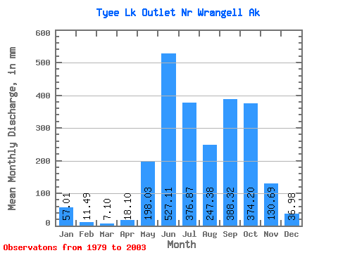
| Statistic | Jan | Feb | Mar | Apr | May | Jun | Jul | Aug | Sep | Oct | Nov | Dec | Annual |
|---|---|---|---|---|---|---|---|---|---|---|---|---|---|
| Mean | 57.02 | 11.57 | 7.12 | 18.12 | 198.03 | 527.10 | 376.79 | 247.32 | 388.36 | 374.14 | 130.66 | 36.97 | 2205.96 |
| Standard Deviation | 157.71 | 33.84 | 22.69 | 36.21 | 190.22 | 127.68 | 168.04 | 138.99 | 197.42 | 221.35 | 116.30 | 43.74 | 776.10 |
| Min | 0.00 | 0.00 | 0.00 | 0.00 | 0.00 | 339.82 | 109.86 | 38.22 | 79.88 | 131.55 | 9.82 | 0.00 | 1423.40 |
| Max | 569.95 | 122.03 | 81.99 | 121.40 | 547.61 | 755.16 | 607.01 | 430.88 | 827.73 | 1009.05 | 430.88 | 128.12 | 4071.80 |
| Coefficient of Variation | 2.77 | 2.92 | 3.18 | 2.00 | 0.96 | 0.24 | 0.45 | 0.56 | 0.51 | 0.59 | 0.89 | 1.18 | 0.35 |
 Return to R-Arctic Net Home Page