|
|
|||||||||||||||||
| Point ID: 9267 | Downloads | Plots | Site Data | Code: 15012000 |
|
|
|||||||||||||||||
| Download | |
|---|---|
| Site Descriptor Information | Site Time Series Data |
| Link to all available data | |
| View: | Time Series | All |
| Units: | m3/s |
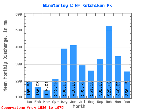
| Statistic | Jan | Feb | Mar | Apr | May | Jun | Jul | Aug | Sep | Oct | Nov | Dec | Annual |
|---|---|---|---|---|---|---|---|---|---|---|---|---|---|
| Mean | 195.88 | 167.46 | 144.96 | 213.16 | 390.64 | 410.17 | 292.69 | 261.90 | 332.61 | 524.99 | 346.86 | 256.13 | 3534.86 |
| Standard Deviation | 153.06 | 121.37 | 80.03 | 84.58 | 89.14 | 85.53 | 92.87 | 122.58 | 125.38 | 171.90 | 132.98 | 143.60 | 476.62 |
| Min | 18.95 | 10.57 | 44.52 | 66.51 | 212.05 | 175.96 | 80.47 | 51.79 | 106.77 | 184.28 | 87.55 | 48.96 | 2647.90 |
| Max | 760.03 | 563.48 | 283.69 | 421.05 | 620.59 | 620.49 | 426.21 | 506.02 | 644.71 | 953.60 | 705.36 | 645.41 | 4405.65 |
| Coefficient of Variation | 0.78 | 0.72 | 0.55 | 0.40 | 0.23 | 0.21 | 0.32 | 0.47 | 0.38 | 0.33 | 0.38 | 0.56 | 0.14 |
 Return to R-Arctic Net Home Page