|
|
|||||||||||||||||
| Point ID: 9243 | Downloads | Plots | Site Data | Code: 15041200 |
|
|
|||||||||||||||||
| Download | |
|---|---|
| Site Descriptor Information | Site Time Series Data |
| Link to all available data | |
|
|
| View: | Statistics | Time Series |
| Units: | mm |
| Statistic | Jan | Feb | Mar | Apr | May | Jun | Jul | Aug | Sep | Oct | Nov | Dec | Annual |
|---|---|---|---|---|---|---|---|---|---|---|---|---|---|
| Mean | 62.05 | 54.72 | 72.87 | 121.03 | 564.55 | 970.79 | 913.39 | 748.72 | 549.08 | 325.34 | 130.61 | 94.80 | 383.98 |
| Standard Deviation | 24.78 | 17.77 | 64.12 | 38.45 | 191.54 | 181.91 | 149.19 | 123.72 | 131.64 | 102.42 | 46.73 | 37.87 | 54.83 |
| Min | 31.86 | 29.46 | 38.47 | 52.96 | 273.30 | 656.10 | 709.02 | 527.06 | 316.65 | 177.40 | 70.44 | 35.57 | 294.59 |
| Max | 119.57 | 104.25 | 297.25 | 192.98 | 957.02 | 1395.36 | 1163.27 | 943.77 | 751.81 | 488.57 | 244.45 | 187.26 | 452.05 |
| Coefficient of Variation | 0.40 | 0.33 | 0.88 | 0.32 | 0.34 | 0.19 | 0.16 | 0.17 | 0.24 | 0.32 | 0.36 | 0.40 | 0.14 |
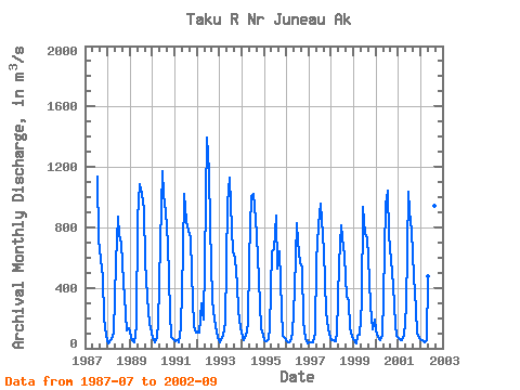
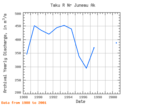
| Year | Jan | Feb | Mar | Apr | May | Jun | Jul | Aug | Sep | Oct | Nov | Dec | Annual | 1987 | 1138.97 | 721.71 | 593.27 | 468.23 | 197.26 | 84.01 | 1988 | 31.86 | 53.55 | 59.49 | 107.36 | 572.81 | 867.53 | 747.20 | 690.93 | 431.74 | 338.65 | 116.04 | 131.58 | 345.73 | 1989 | 75.38 | 56.15 | 39.78 | 144.87 | 866.50 | 1086.05 | 1019.68 | 918.93 | 566.93 | 339.24 | 161.09 | 136.83 | 450.95 | 1990 | 68.74 | 39.86 | 72.36 | 157.90 | 697.87 | 1169.30 | 1016.57 | 910.34 | 695.18 | 232.41 | 74.86 | 62.41 | 433.15 | 1991 | 47.46 | 55.58 | 38.47 | 138.13 | 642.15 | 1023.65 | 840.74 | 776.34 | 732.75 | 488.57 | 144.83 | 103.65 | 419.36 | 1992 | 108.29 | 104.25 | 297.25 | 192.98 | 565.61 | 1395.36 | 1163.27 | 813.79 | 316.65 | 192.26 | 101.68 | 72.65 | 443.67 | 1993 | 41.09 | 70.81 | 86.40 | 165.29 | 957.02 | 1125.88 | 952.27 | 639.50 | 595.14 | 417.24 | 244.45 | 129.49 | 452.05 | 1994 | 75.72 | 54.05 | 80.44 | 158.38 | 592.28 | 1010.53 | 1018.95 | 852.98 | 751.81 | 457.04 | 132.22 | 86.25 | 439.22 | 1995 | 53.93 | 48.31 | 57.87 | 135.05 | 644.80 | 656.10 | 876.82 | 527.06 | 641.19 | 257.83 | 82.95 | 71.59 | 337.79 | 1996 | 46.72 | 37.63 | 43.19 | 96.40 | 393.32 | 829.02 | 709.02 | 559.21 | 537.13 | 177.40 | 70.44 | 35.57 | 294.59 | 1997 | 37.62 | 42.19 | 39.27 | 104.97 | 576.78 | 816.94 | 958.85 | 752.68 | 643.74 | 242.87 | 124.43 | 98.01 | 369.86 | 1998 | 54.20 | 54.18 | 49.52 | 103.13 | 557.30 | 812.98 | 736.33 | 612.74 | 340.41 | 313.62 | 129.39 | 73.94 | 319.81 | 1999 | 51.51 | 29.46 | 79.43 | 92.26 | 306.00 | 938.70 | 757.52 | 733.50 | 450.67 | 281.74 | 126.27 | 187.26 | 336.19 | 2000 | 119.57 | 72.75 | 56.81 | 80.58 | 343.49 | 952.86 | 1045.07 | 748.75 | 583.71 | 413.13 | 157.37 | 80.43 | 387.88 | 2001 | 66.02 | 50.78 | 50.83 | 85.22 | 273.30 | 1038.66 | 906.32 | 777.25 | 473.93 | 259.84 | 95.83 | 68.28 | 345.52 | 2002 | 52.56 | 51.25 | 41.93 | 52.96 | 479.05 | 838.27 | 726.74 | 943.77 | 431.08 |
|---|
 Return to R-Arctic Net Home Page
