|
|
|||||||||||||||||
| Point ID: 9234 | Downloads | Plots | Site Data | Code: 15080500 |
|
|
|||||||||||||||||
| Download | |
|---|---|
| Site Descriptor Information | Site Time Series Data |
| Link to all available data | |
|
|
| View: | Statistics | Time Series |
| Units: | mm |
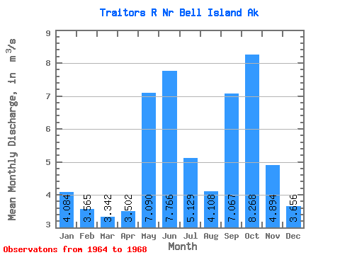
| Statistic | Jan | Feb | Mar | Apr | May | Jun | Jul | Aug | Sep | Oct | Nov | Dec | Annual |
|---|---|---|---|---|---|---|---|---|---|---|---|---|---|
| Mean | 4.08 | 3.56 | 3.34 | 3.50 | 7.09 | 7.77 | 5.13 | 4.11 | 7.07 | 8.27 | 4.89 | 3.66 | 4.79 |
| Standard Deviation | 1.84 | 0.74 | 2.38 | 1.11 | 1.95 | 1.78 | 1.75 | 1.69 | 4.30 | 1.63 | 0.72 | 0.55 | 0.77 |
| Min | 1.98 | 2.76 | 1.17 | 1.88 | 4.84 | 6.33 | 3.27 | 1.30 | 1.11 | 6.78 | 4.02 | 2.96 | 3.90 |
| Max | 6.30 | 4.51 | 5.47 | 4.28 | 8.84 | 10.84 | 7.56 | 5.42 | 11.75 | 10.59 | 5.74 | 4.30 | 5.28 |
| Coefficient of Variation | 0.45 | 0.21 | 0.71 | 0.32 | 0.28 | 0.23 | 0.34 | 0.41 | 0.61 | 0.20 | 0.15 | 0.15 | 0.16 |
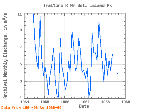
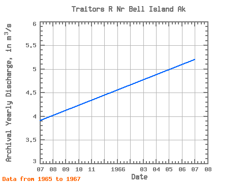
| Year | Jan | Feb | Mar | Apr | May | Jun | Jul | Aug | Sep | Oct | Nov | Dec | Annual | 1964 | 10.84 | 7.56 | 5.37 | 4.44 | 10.59 | 5.74 | 3.66 | 1965 | 4.70 | 3.27 | 1.40 | 3.68 | 4.84 | 6.86 | 3.27 | 1.30 | 1.11 | 7.99 | 4.73 | 3.71 | 3.90 | 1966 | 1.98 | 2.76 | 5.33 | 4.16 | 8.84 | 7.39 | 4.28 | 4.55 | 8.05 | 6.78 | 4.02 | 4.30 | 5.20 | 1967 | 3.36 | 4.51 | 1.17 | 1.88 | 8.59 | 6.33 | 6.31 | 5.42 | 9.99 | 7.71 | 5.09 | 2.96 | 5.28 | 1968 | 6.30 | 3.72 | 5.47 | 4.28 | 6.09 | 7.40 | 4.22 | 3.89 | 11.75 |
|---|
 Return to R-Arctic Net Home Page