|
|
|||||||||||||||||
| Point ID: 9209 | Downloads | Plots | Site Data | Code: 15238860 |
|
|
|||||||||||||||||
| Download | |
|---|---|
| Site Descriptor Information | Site Time Series Data |
| Link to all available data | |

|
|
| View: | Statistics | Time Series |
| Units: | mm |
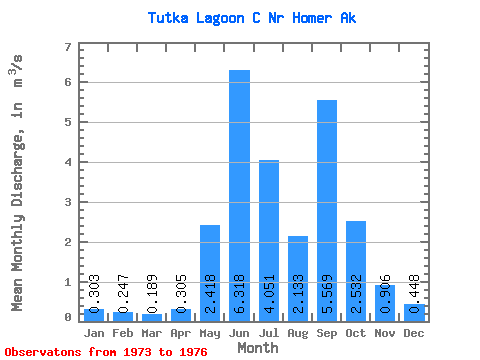
| Statistic | Jan | Feb | Mar | Apr | May | Jun | Jul | Aug | Sep | Oct | Nov | Dec | Annual |
|---|---|---|---|---|---|---|---|---|---|---|---|---|---|
| Mean | 0.30 | 0.25 | 0.19 | 0.30 | 2.42 | 6.32 | 4.05 | 2.13 | 5.57 | 2.53 | 0.91 | 0.45 | 2.18 |
| Standard Deviation | 0.12 | 0.05 | 0.01 | 0.10 | 0.72 | 0.70 | 1.16 | 0.54 | 2.10 | 1.21 | 0.70 | 0.26 | 0.06 |
| Min | 0.21 | 0.20 | 0.18 | 0.18 | 1.87 | 5.79 | 2.87 | 1.59 | 3.43 | 1.14 | 0.42 | 0.28 | 2.13 |
| Max | 0.44 | 0.30 | 0.20 | 0.37 | 3.23 | 7.12 | 5.20 | 2.88 | 8.46 | 3.25 | 1.70 | 0.75 | 2.22 |
| Coefficient of Variation | 0.40 | 0.22 | 0.05 | 0.34 | 0.30 | 0.11 | 0.29 | 0.25 | 0.38 | 0.48 | 0.77 | 0.58 | 0.03 |
| Year | Jan | Feb | Mar | Apr | May | Jun | Jul | Aug | Sep | Oct | Nov | Dec | Annual | 1973 | 2.01 | 3.43 | 1.14 | 0.42 | 0.28 | 1974 | 0.21 | 0.20 | 0.20 | 0.36 | 3.23 | 6.05 | 2.87 | 1.59 | 5.20 | 3.25 | 1.70 | 0.75 | 2.13 | 1975 | 0.44 | 0.30 | 0.18 | 0.18 | 1.87 | 7.12 | 5.20 | 2.05 | 5.18 | 3.21 | 0.59 | 0.32 | 2.22 | 1976 | 0.26 | 0.24 | 0.19 | 0.37 | 2.15 | 5.79 | 4.08 | 2.88 | 8.46 |
|---|
 Return to R-Arctic Net Home Page