|
|
|||||||||||||||||
| Point ID: 9206 | Downloads | Plots | Site Data | Code: 15238653 |
|
|
|||||||||||||||||
| Download | |
|---|---|
| Site Descriptor Information | Site Time Series Data |
| Link to all available data | |
|
|
| View: | Statistics | Time Series |
| Units: | mm |
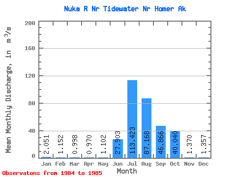
| Statistic | Jan | Feb | Mar | Apr | May | Jun | Jul | Aug | Sep | Oct | Nov | Dec | Annual |
|---|---|---|---|---|---|---|---|---|---|---|---|---|---|
| Mean | 2.05 | 1.15 | 1.00 | 0.97 | 1.10 | 27.90 | 113.42 | 87.17 | 46.87 | 40.04 | 1.37 | 1.36 | |
| Standard Deviation | 21.06 | ||||||||||||
| Min | 2.05 | 1.15 | 1.00 | 0.97 | 1.10 | 27.90 | 113.42 | 87.17 | 31.97 | 40.04 | 1.37 | 1.36 | |
| Max | 2.05 | 1.15 | 1.00 | 0.97 | 1.10 | 27.90 | 113.42 | 87.17 | 61.76 | 40.04 | 1.37 | 1.36 | |
| Coefficient of Variation | 0.45 |
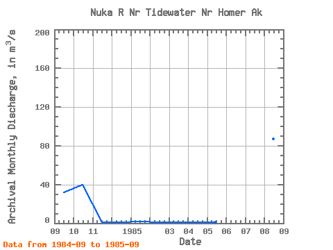
| Year | Jan | Feb | Mar | Apr | May | Jun | Jul | Aug | Sep | Oct | Nov | Dec | Annual | 1984 | 31.97 | 40.04 | 1.37 | 1.36 | 1985 | 2.05 | 1.15 | 1.00 | 0.97 | 1.10 | 27.90 | 113.42 | 87.17 | 61.76 |
|---|
 Return to R-Arctic Net Home Page