|
|
|||||||||||||||||
| Point ID: 9193 | Downloads | Plots | Site Data | Code: 15226600 |
|
|
|||||||||||||||||
| Download | |
|---|---|
| Site Descriptor Information | Site Time Series Data |
| Link to all available data | |
|
|
| View: | Statistics | Time Series |
| Units: | mm |
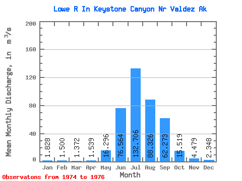
| Statistic | Jan | Feb | Mar | Apr | May | Jun | Jul | Aug | Sep | Oct | Nov | Dec | Annual |
|---|---|---|---|---|---|---|---|---|---|---|---|---|---|
| Mean | 1.83 | 1.50 | 1.37 | 1.54 | 16.30 | 76.56 | 132.71 | 88.33 | 62.27 | 15.52 | 4.48 | 2.35 | 34.39 |
| Standard Deviation | 0.08 | 0.12 | 0.14 | 0.21 | 4.97 | 6.80 | 20.31 | 22.21 | 15.38 | 3.28 | 2.64 | 0.74 | |
| Min | 1.77 | 1.42 | 1.27 | 1.39 | 12.78 | 71.75 | 118.35 | 72.62 | 51.40 | 13.20 | 2.62 | 1.83 | 34.39 |
| Max | 1.88 | 1.58 | 1.47 | 1.69 | 19.81 | 81.37 | 147.06 | 104.03 | 73.15 | 17.84 | 6.34 | 2.87 | 34.39 |
| Coefficient of Variation | 0.04 | 0.08 | 0.10 | 0.14 | 0.30 | 0.09 | 0.15 | 0.25 | 0.25 | 0.21 | 0.59 | 0.31 |
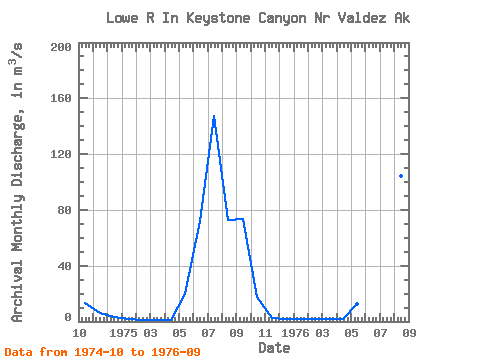
| Year | Jan | Feb | Mar | Apr | May | Jun | Jul | Aug | Sep | Oct | Nov | Dec | Annual | 1974 | 13.20 | 6.34 | 2.87 | 1975 | 1.88 | 1.42 | 1.27 | 1.39 | 19.81 | 71.75 | 147.06 | 72.62 | 73.15 | 17.84 | 2.62 | 1.83 | 34.39 | 1976 | 1.77 | 1.58 | 1.47 | 1.69 | 12.78 | 81.37 | 118.35 | 104.03 | 51.40 |
|---|
 Return to R-Arctic Net Home Page