|
|
|||||||||||||||||
| Point ID: 9190 | Downloads | Plots | Site Data | Code: 15219000 |
|
|
|||||||||||||||||
| Download | |
|---|---|
| Site Descriptor Information | Site Time Series Data |
| Link to all available data | |
| View: | Time Series | All |
| Units: | m3/s |
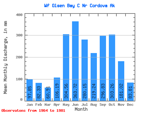
| Statistic | Jan | Feb | Mar | Apr | May | Jun | Jul | Aug | Sep | Oct | Nov | Dec | Annual |
|---|---|---|---|---|---|---|---|---|---|---|---|---|---|
| Mean | 97.91 | 83.07 | 60.95 | 106.18 | 304.52 | 363.74 | 280.15 | 219.28 | 296.78 | 303.30 | 180.96 | 83.83 | 2372.61 |
| Standard Deviation | 144.19 | 112.52 | 55.23 | 50.72 | 50.12 | 86.36 | 101.47 | 116.15 | 171.23 | 113.05 | 188.55 | 68.51 | 411.49 |
| Min | 8.38 | 10.22 | 9.28 | 11.48 | 219.19 | 245.24 | 117.92 | 86.38 | 106.70 | 123.00 | 18.55 | 14.54 | 1828.44 |
| Max | 478.01 | 420.84 | 157.62 | 209.33 | 405.99 | 578.89 | 502.34 | 457.49 | 646.77 | 497.32 | 819.01 | 241.86 | 3268.24 |
| Coefficient of Variation | 1.47 | 1.35 | 0.91 | 0.48 | 0.17 | 0.24 | 0.36 | 0.53 | 0.58 | 0.37 | 1.04 | 0.82 | 0.17 |
 Return to R-Arctic Net Home Page