|
|
|||||||||||||||||
| Point ID: 9177 | Downloads | Plots | Site Data | Code: 15100000 |
|
|
|||||||||||||||||
| Download | |
|---|---|
| Site Descriptor Information | Site Time Series Data |
| Link to all available data | |
| View: | Time Series | All |
| Units: | m3/s |
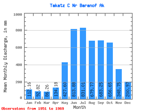
| Statistic | Jan | Feb | Mar | Apr | May | Jun | Jul | Aug | Sep | Oct | Nov | Dec | Annual |
|---|---|---|---|---|---|---|---|---|---|---|---|---|---|
| Mean | 112.16 | 93.62 | 86.27 | 134.18 | 427.52 | 813.87 | 830.92 | 679.65 | 683.26 | 656.54 | 348.75 | 200.94 | 5087.50 |
| Standard Deviation | 72.48 | 65.31 | 49.44 | 41.84 | 114.13 | 142.49 | 120.05 | 111.21 | 228.96 | 216.88 | 123.61 | 120.51 | 450.50 |
| Min | 31.81 | 30.49 | 28.43 | 54.27 | 241.06 | 586.58 | 589.93 | 470.50 | 435.04 | 391.56 | 162.72 | 61.83 | 4232.76 |
| Max | 294.41 | 298.78 | 237.66 | 200.43 | 623.54 | 1072.01 | 1015.27 | 905.96 | 1263.03 | 1127.90 | 649.77 | 469.10 | 5950.10 |
| Coefficient of Variation | 0.65 | 0.70 | 0.57 | 0.31 | 0.27 | 0.17 | 0.14 | 0.16 | 0.34 | 0.33 | 0.35 | 0.60 | 0.09 |
 Return to R-Arctic Net Home Page