|
|
|||||||||||||||||
| Point ID: 9168 | Downloads | Plots | Site Data | Code: 15224000 |
|
|
|||||||||||||||||
| Download | |
|---|---|
| Site Descriptor Information | Site Time Series Data |
| Link to all available data | |
|
|
| View: | Statistics | Time Series |
| Units: | mm |
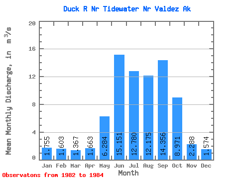
| Statistic | Jan | Feb | Mar | Apr | May | Jun | Jul | Aug | Sep | Oct | Nov | Dec | Annual |
|---|---|---|---|---|---|---|---|---|---|---|---|---|---|
| Mean | 1.75 | 1.60 | 1.37 | 1.66 | 6.28 | 15.15 | 12.78 | 12.18 | 14.36 | 8.97 | 2.29 | 1.57 | 6.99 |
| Standard Deviation | 0.18 | 0.59 | 0.83 | 0.48 | 2.22 | 1.81 | 1.81 | 3.57 | 12.04 | 1.83 | 0.42 | 0.60 | |
| Min | 1.63 | 1.19 | 0.78 | 1.18 | 3.99 | 13.11 | 10.79 | 8.91 | 6.16 | 7.14 | 1.83 | 1.15 | 6.99 |
| Max | 1.88 | 2.02 | 1.96 | 2.14 | 8.43 | 16.55 | 14.32 | 15.98 | 28.18 | 10.81 | 2.65 | 2.00 | 6.99 |
| Coefficient of Variation | 0.10 | 0.37 | 0.61 | 0.29 | 0.35 | 0.12 | 0.14 | 0.29 | 0.84 | 0.20 | 0.18 | 0.38 |
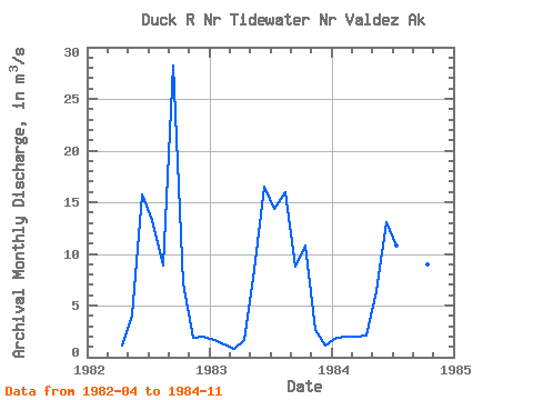
| Year | Jan | Feb | Mar | Apr | May | Jun | Jul | Aug | Sep | Oct | Nov | Dec | Annual | 1982 | 1.18 | 3.99 | 15.79 | 13.24 | 8.91 | 28.18 | 7.14 | 1.83 | 2.00 | 1983 | 1.63 | 1.19 | 0.78 | 1.67 | 8.43 | 16.55 | 14.32 | 15.98 | 8.73 | 10.81 | 2.65 | 1.15 | 6.99 | 1984 | 1.88 | 2.02 | 1.96 | 2.14 | 6.42 | 13.11 | 10.79 | 11.64 | 6.16 | 8.96 | 2.38 |
|---|
 Return to R-Arctic Net Home Page