|
|
|||||||||||||||||
| Point ID: 9164 | Downloads | Plots | Site Data | Code: 15107910 |
|
|
|||||||||||||||||
| Download | |
|---|---|
| Site Descriptor Information | Site Time Series Data |
| Link to all available data | |
|
|
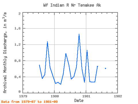
| View: | Statistics | Time Series |
| Units: | mm |
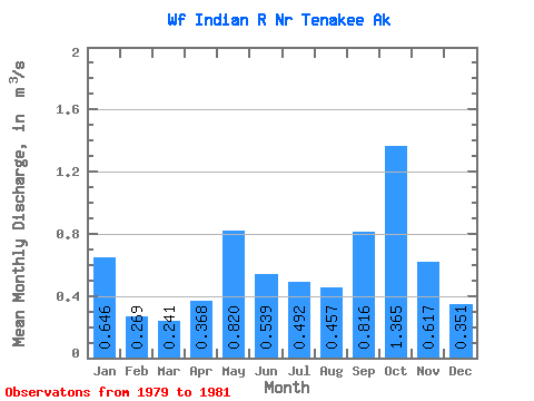
| Statistic | Jan | Feb | Mar | Apr | May | Jun | Jul | Aug | Sep | Oct | Nov | Dec | Annual |
|---|---|---|---|---|---|---|---|---|---|---|---|---|---|
| Mean | 0.65 | 0.27 | 0.24 | 0.37 | 0.82 | 0.54 | 0.49 | 0.46 | 0.82 | 1.36 | 0.62 | 0.35 | 0.55 |
| Standard Deviation | 0.58 | 0.01 | 0.04 | 0.14 | 0.23 | 0.25 | 0.18 | 0.13 | 0.48 | 0.14 | 0.03 | 0.13 | |
| Min | 0.23 | 0.26 | 0.21 | 0.27 | 0.66 | 0.36 | 0.34 | 0.36 | 0.45 | 1.27 | 0.60 | 0.26 | 0.55 |
| Max | 1.06 | 0.28 | 0.27 | 0.47 | 0.98 | 0.72 | 0.69 | 0.61 | 1.35 | 1.46 | 0.64 | 0.44 | 0.55 |
| Coefficient of Variation | 0.90 | 0.04 | 0.18 | 0.37 | 0.28 | 0.47 | 0.36 | 0.29 | 0.58 | 0.10 | 0.04 | 0.36 |
| Year | Jan | Feb | Mar | Apr | May | Jun | Jul | Aug | Sep | Oct | Nov | Dec | Annual | 1979 | 0.69 | 0.36 | 0.45 | 1.27 | 0.64 | 0.44 | 1980 | 0.23 | 0.26 | 0.21 | 0.47 | 0.98 | 0.72 | 0.34 | 0.41 | 0.64 | 1.46 | 0.60 | 0.26 | 0.55 | 1981 | 1.06 | 0.28 | 0.27 | 0.27 | 0.66 | 0.36 | 0.44 | 0.61 | 1.35 |
|---|
 Return to R-Arctic Net Home Page