|
|
|||||||||||||||||
| Point ID: 9154 | Downloads | Plots | Site Data | Code: 15106980 |
|
|
|||||||||||||||||
| Download | |
|---|---|
| Site Descriptor Information | Site Time Series Data |
| Link to all available data | |
| View: | Time Series | All |
| Units: | m3/s |
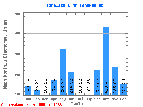
| Statistic | Jan | Feb | Mar | Apr | May | Jun | Jul | Aug | Sep | Oct | Nov | Dec | Annual |
|---|---|---|---|---|---|---|---|---|---|---|---|---|---|
| Mean | 148.25 | 126.29 | 105.19 | 174.37 | 323.94 | 214.35 | 103.21 | 102.83 | 220.61 | 429.43 | 235.07 | 154.55 | 2323.51 |
| Standard Deviation | 131.77 | 106.31 | 63.59 | 63.27 | 107.52 | 101.97 | 43.67 | 60.74 | 108.98 | 192.97 | 130.26 | 105.38 | 348.46 |
| Min | 20.98 | 17.91 | 33.69 | 60.25 | 127.65 | 66.44 | 33.40 | 28.45 | 63.52 | 179.63 | 50.23 | 28.18 | 1771.71 |
| Max | 437.34 | 376.11 | 259.40 | 294.89 | 576.42 | 435.76 | 188.39 | 270.90 | 558.94 | 999.31 | 410.32 | 417.09 | 2965.14 |
| Coefficient of Variation | 0.89 | 0.84 | 0.60 | 0.36 | 0.33 | 0.48 | 0.42 | 0.59 | 0.49 | 0.45 | 0.55 | 0.68 | 0.15 |
 Return to R-Arctic Net Home Page