|
|
|||||||||||||||||
| Point ID: 9135 | Downloads | Plots | Site Data | Code: 07SB019 |
|
|
|||||||||||||||||
| Download | |
|---|---|
| Site Descriptor Information | Site Time Series Data |
| Link to all available data | |
| View: | Time Series | All |
| Units: | m3/s |
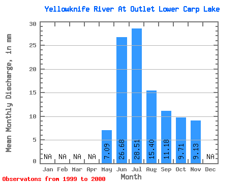
| Statistic | Jan | Feb | Mar | Apr | May | Jun | Jul | Aug | Sep | Oct | Nov | Dec | Annual |
|---|---|---|---|---|---|---|---|---|---|---|---|---|---|
| Mean | 7.09 | 26.68 | 28.51 | 15.40 | 11.18 | 9.71 | 9.13 | ||||||
| Standard Deviation | 16.34 | 9.71 | 2.45 | 1.68 | 1.18 | ||||||||
| Min | 7.09 | 15.12 | 21.65 | 13.67 | 9.99 | 8.87 | 9.13 | ||||||
| Max | 7.09 | 38.23 | 35.37 | 17.13 | 12.37 | 10.54 | 9.13 | ||||||
| Coefficient of Variation | 0.61 | 0.34 | 0.16 | 0.15 | 0.12 |
 Return to R-Arctic Net Home Page